PREDICTING DAMQUAKES-4(continued from Predicting Earthquakes-Dam Dynamics-3)
R. Ashok Kumar, B.E.,M.E (Power), Negentropist, Bombay Sarvodaya Mandal, 299, Tardeo Road, Nana Chowk, Mumbai-400007.

May 1, 2016 at 16:20 UTC
The peak magnitude damquake for May 2016 is expected to occur between 13 to 20 May 2016 of 7.7 MM moment magnitude.
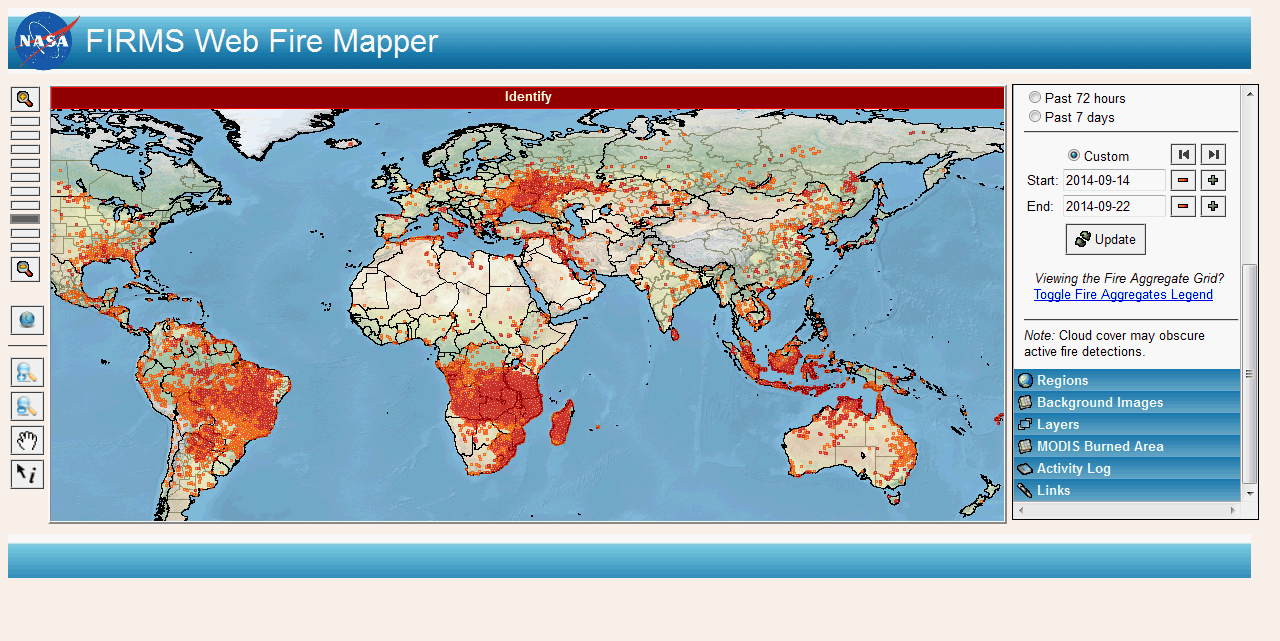
The likely location is the Himalayas. Because see how the Himalayas have heated up as shown by the UTTARKHAND fires as on 2 May 2016 at 12:32 UTC:
 Look at the fires along the HImalayas:
Total number of fires detected : 4258
[ONLY TOP 5 RESULTS ARE SHOWN.]
Simultaneously Fort McMurray in Alberta, Canada was engulfed in flames, 88000 evacuated:

April 24 2016 at 15:17 UTC
The web fire mapper shows hotspots for April 24 a year after the Nepal 7.8 MM damquake:
 So far the peak magnitude earthquake a 7.8 MM damquake occurred in Ecuador as predicted by me:
April 2 06:55 UTC 2016
Peak Magnitude Earthquake in April 2016: Prediction
7.6 MM major damquake between 14 and 21 April 2016.
Candidates for the location:
The Himalayas, The Pacific Rim, Andaman- Sumatra Bay, Gujarat.
March 2 14:21 UTC 2016
As predicted below a major earthquake has occurred, a little sooner than expected:
Are there any damages?
Re:
http://www.deccanherald.com/content/532212/govt-plans-set-up-more.html
March 1 2016 at 12:17 UTC
The peak magnitude earthquake during March 2016 is expected to be 8.1 MM between 13 to 19 March 2016 and the candidates for location appear to be the Himalayas or the North West Sumatra Region or the Pacific Rim Region, most probably Japan.
February 19 2016 at 06: 31 UTC

February 7 2016 at 0804 UTC
There was a deadly strong magnitude damquake of 6.4 MM at Taiwan on 5th February 2016:
Look at the number of hotspots in the world past 24 hrs on 1 to 6 February 2016, and at the quake location at the designated times, all UTC:
6 17394 at 15:03:21 Taiwan 24:00 5
5 9131 at 12:56:18 Taiwan 24:00 0 Quake at 19:57
4 18518 at 14:56:54 Taiwan 24:00 0
3 10107 at 13:05:11 Taiwan 24:00 2
2 15088 at 14:04:20 Taiwan 24:00 0
1 10175 at 12:46:37 Taiwan 24:00 0
This is sequence for all the quakes caused by dams, samples of which have been analysed in this running narrative! See the proof that dams of the world are causing these quakes at
http://predictingquakes.blogspot.in/2015/04/the-science-of-dams-causing-earthquakes.html
If you dear reader check out this and decide for yourself one way or the other, leave a comment so life may be saved. It may be too late for India as my research shows that one scenario like that of the atmospheric nuclear tests results in the killing of all babies born in 2028-2029 by nuclear contamination caused by the Fukushima extinction breeding event caused by the dams(ten times that caused by the tests).
See
http://glaringlacuna.blogspot.in/2012/01/nuclear-effect-in-causing-earthquakes.html
The implication for prediction of an impending damquake is to watch out when the number of hotspots caused by the direct heating up of the earth by the world's dams registers a steep fall from a steep total.
Read these dam related events in modern civilization:
Gov. Andrew Cuomo, Feb 6, 2016: “Yesterday I learned that radioactive tritium-contaminated water leaked… The company reported alarming levels of radioactivity at three monitoring wells, with one well’s radioactivity increasing nearly 65,000 percent.”
Gov. Cuomo’s letter to Commissioner Zucker (Dept. of Health) & Acting Commissioner Seggos (Dept. of Environmental Conservation), Feb 6, 2016: “I am deeply concerned… Indian Point has experienced significant failure in its operation and maintenance… levels of radioactivity reported this week are significantly higher than in past incidents… Our first concern is for the health and safety of the residents… I am directing you to fully investigate this incident… to determine the extent of the release, its likely duration, its causes, its potential impacts to the environment and public health, and how the release can be contained.”
Ellen Jaffee, New York Assemblymember, Feb 6, 2016: “I am concerned about the alarming increase in radioactive water leaking… My primary concern is the potential impact this… may have on public health and our environment.”
CBS 6 Albany transcript, Feb 6, 2016: “[The NRC] says that exposure to high levels of tritium may cause cancer in humans or genetic defects.”
February 4 2016 at 558 UTC
Peak Magnitude Damquake for February 2016
See
https://blogger.googleusercontent.com/img/b/R29vZ2xl/AVvXsEh-pK3GMtRl8MXO2aR5VHeoxrNwSp5-kPNgnVNsanmeVY2oZdIG2alnkMNDjCvuE74s1gnOaPtk5Sa5xIehqebkvUdnZtz_hwNtoml4YI44h_FQRt3nj4RtTFurDEFqsaacW2Fzsw/s1600-h/image004.gif
A peak magnitude damquake is expected in the range 6.9 to 7.6 MM between 12 to 18 February.
The expected location is one of the Himalayas, Maharashtra, Bihar or the North East of India or Myanmar or China or Indonesia or Vietnam or Japan or the Pacific Rim region.
See the hotspot map:

January 24, 1331 UTC 2016
As expected a 7.1 MM magnitude major damquake occurred in Alaska:

Note that the estimated location included the Rift Valley which has a longitude band of 25. And the location was 180-25 or 155 or Alaska a supplementary to Rift Valley.
January 4, 12:19 UTC, 2016.
Prediction of the Peak Magnitude Earthquake for January 2016
See https://blogger.googleusercontent.com/img/b/R29vZ2xl/AVvXsEh-pK3GMtRl8MXO2aR5VHeoxrNwSp5-kPNgnVNsanmeVY2oZdIG2alnkMNDjCvuE74s1gnOaPtk5Sa5xIehqebkvUdnZtz_hwNtoml4YI44h_FQRt3nj4RtTFurDEFqsaacW2Fzsw/s1600-h/image004.gif
7.1 to 7.7 MM between 11 to 17 January 2016.
Expected candidates for the location of the peak magnitude damquake:
Western Turkey or Rift Valley or The Himalayas or Andaman Sumatra Bay or Indonesia or China/Taiwan or Japan or New Zealand.
December 3 to 7, 2015
The peak magnitude damquake for December 2015 is
7.1 to 8.7 MM between 9 and 16 December 2015.
Brazil is the expected location(maximum number of hotspots as seen in Web Fire Mapper of 3 December 2015 at 0700 UTC) or Tamilnadu coast or Andaman Sumatra Bay or Japan. Looking at the dam dynamics today 7 December 2015, which saw a major fire in Kandivali slum(Latitude = 19.2009, Longitude = 72.8771) and a major dam quake in Tajikistan:
we may expect the peak magnitude location may also be the Himalayas or the Pacific Rim, probably West Coast of South America.
See also
http://trmm.gsfc.nasa.gov/trmm_rain/Events/latest_big_3hrly.gif
and
http://trmm.gsfc.nasa.gov/trmm_rain/Events/big_global_accumlation.gif
30 November 2015 at 0519 UTC
So far in the Month of November there were two major deep focus earthquakes of magnitude 7.6 in Peru and Brazil:
The prediction was for a major earthquake between 7.2 to 7.9 MM between 14 to 21 November and in the 70-75 longitude band or as shown previously in the -70 to -75 longitude band. The deep focus quake occurred in the latter band. But November is still not over so we may expect a major shallow quake still in South America or Japan or on the Pacific Rim or the Himalayas or the Andaman Nicobar Isles Region.
31 October 2015 at 23:39 UTC
The total number of hotspots as shown by web fire mapper is 5394 during past 24 hrs ended at 10:16:57 and about 50% is concentrated in North India:
Total number of fires detected : 2386
[ONLY TOP 5 RESULTS ARE SHOWN.]
So hereabouts or in the Himalayas we may expect the peak magnitude damquake for November 2015:
Peak Magnitude: 7.2 to 7.9 MM between 14th to 21st November 2015.
There has been a deep focus damquake in Western Honshu Region:
And a hotspot:
Total number of fires detected : 1
[ONLY TOP 5 RESULTS ARE SHOWN.]
Throughout the 130-135 longitude band we see intense hotspots:
Total number of fires detected : 358
[ONLY TOP 5 RESULTS ARE SHOWN.]
Total number of fires detected : 551
[ONLY TOP 5 RESULTS ARE SHOWN.]
Total number of fires detected : 671
[ONLY TOP 5 RESULTS ARE SHOWN.]
So we may expect a major damquake or a dam related damage causing event in this longitude band, say in Japan or Indonesia.
26 October 2015 at 13:35 UTC
A major damquake has occurred as predicted by me:
As is always the case a deep focus damquake preceded this:
The earthquake map:

Initial newsreport:
180 killed.Revised: 230 killed(27 October 2015).
http://www.cnn.com/2015/10/26/asia/afghanistan-earthquake/index.html
How they felt it:
http://earthquake.usgs.gov/earthquakes/eventpage/us10003re5#impact_dyfi
Another newsreport:
http://www.deccanherald.com/content/508386/over-130-dead-pakistan-quake.html
Later newsreport:
http://www.deccanherald.com/content/508477/over-230-killed-pak-af.html
25 October 2015 at 21:32 UTC
Huge conglomerations of hotspots in Brazil, Madagascar, North India, Indonesia, South East Russia of thousands of hotspots. The dams are creating havoc! Dam related events like Patricia Hurricane's effects, earthquakes and volcanoes may occur in the coming days and weeks.
The hotspots:

The hotspots during 23 to 25 October 2015:
Brazil:
Total number of fires detected : 1681
[ONLY TOP 5 RESULTS ARE SHOWN.]
Madagascar:
Total number of fires detected : 1873
[ONLY TOP 5 RESULTS ARE SHOWN.]
North India:
Total number of fires detected : 1068
[ONLY TOP 5 RESULTS ARE SHOWN.]
Indonesia:
Total number of fires detected : 2708
[ONLY TOP 5 RESULTS ARE SHOWN.]
Papua Region:
Total number of fires detected : 1185
[ONLY TOP 5 RESULTS ARE SHOWN.]
East Russia Region
Total number of fires detected : 1093
[ONLY TOP 5 RESULTS ARE SHOWN.]
Total number of fires detected : 2332
[ONLY TOP 5 RESULTS ARE SHOWN.]
Remark on 27 October 2015:
Damquake had occurred in Pakistan on 23 October 2015, a precursor to a major quake in the Hindukush mountains on 26th October 2015.:
21 October 2015 at 02:26 UTC
Near Indonesia at Vanuatu a major earthquake occurred as predicted by me:
14 October 2015 at 18:23 UTC
The Web Fire Mapper for 12 to 14 October reveals hotspot clusters in Brazil Region, Southern Africa including Madagascar, Indonesia including the Papua Region of thousands of hotspots in each region. The number of hotspots in the world on 14 October noon 2015 registered 17465 while on the previous day 13 October about noon 2015 it was 9203! This is in line with prediction of 30 Sep 2015 at 1650 UTC(See below).
30 Sep 2015 at 1650 UTC
Prediction of peak magnitude earthquake for October 2015
7.8 MM between 15th to 21 October 2015.
Likely locations: S. America or Africa(Rift Valley), Indonesia, the Himalayas or China or Japan or in the region around Lat 48,Long 40.
17 Sep 2015 7:09:31 UTC
As much more than predicted, a great 8.3 MM earthquake occurred off Chile Coast on 16 September 2015 triggering tsunami:
See newsreport:
http://www.theguardian.com/world/live/2015/sep/17/chile-earthquake-massive-83-magnitude-tremor-strikes-santiago-live-updates
I saw this coming when I noticed enormous number of hotspots in South America yesterday:

2015-09-12 0530 UTC
The peak magnitude earthquake prediction for September 2015 is as follows:
Dam caused and expected between 12th to 18 September 2015 with a magnitude of 7.9 MM in Japan or Indonesia or China or elsewhere on the Pacific Rim or in the Himalayas or in the Turkey Region. Of course a dam related event(flash floods and landslides) is ravaging Japan and threatening its nuclear plants and causing radioactive contamination of the Pacific right now. See enenews:
2015-08-13 at 13:34 UTC
The number of hotspots in the past 24 hours detected by the web fire mapper(NASA) on 12 August 2015 at 09:14: 27 UTC : 24294
The number of hotspots in the past 24 hours detected by the web fire mapper(NASA) on 13 August 2015 at 09:07: 21 UTC : 5844
At 14:50 UTC on 12 August 2015 there was fire followed by massive explosions in the Port City of Tianjin, China,
39.0842,117.2010, in which 54 people were killed and hundreds injured. Is this the disaster portent of the drastic reduction in the number of hotspots observed from 12 to13 August 2015 or a major earthquake is indicated? See Prediction below.
Latest News 2015-08-04 12:22 UTC
Prediction of the peak magnitude earthquake for August 2015
See
https://blogger.googleusercontent.com/img/b/R29vZ2xl/AVvXsEh-pK3GMtRl8MXO2aR5VHeoxrNwSp5-kPNgnVNsanmeVY2oZdIG2alnkMNDjCvuE74s1gnOaPtk5Sa5xIehqebkvUdnZtz_hwNtoml4YI44h_FQRt3nj4RtTFurDEFqsaacW2Fzsw/s1600-h/image004.gif
It is expected to be 7.3 to 7.7 MM magnitude to occur between 14 to 20 August 2015 in the Pacific Rim probably in China or Japan or in Turkey or in the Himalayas or in the Rift Valley Region of Africa.
Modern civilization's dams are also causing its self destruction! The latest: The Himalayan earthquake in Nepal
The dance of the earthquakes around Chernobyl is identical and synchronous to the dance of those around Lumjung, Nepal and to the dance of worldwide earthquakes: 41 year study from 19730601 to 20140531. The dances are determined by the World's dams. The story is the same for all disasters wrought by modern civilization, be it the Air France 447 crash in a thunderstorm or the Air Asia crash in a thunderstorm, the Fukushima China syndrome triple core melt or many more to come.
Modern civilization also wrought with the Nepal damquake a huge number of avalanches on Mt Everest killing many climbers including sherpas.
The actors of modern civilization do not recognise that this is one more disaster of self destruction of modern civilization. Its not the plates, its the dams that are wreaking havoc in the Himalayas. The height of Mt Everest is about 8.9 km. The water pressure head change of the world's dams that was exerted at the centre of gravity of the dams is about 77 million km! And the power of the Water moment exerted by the dams on Mt Everest is about 100000 terawatts equivalent to that of an 8.1 MM moment magnitude great earthquake. See Table below. In 2013 June it was the dams exerting their surges on Mt Kedarnath! In 2015 April its the Mt Everest that bore the brunt of the surges of the world's dams.
In living in this world by his own will and skill, the stupidest peasant or tribesman is more competent than the most intelligent worker or technician or intellectual ina society of specialists (that is modern civilization) - Wendell Berry in the Unsettling of America, Culture and Agriculture.
In 1908, Mahatma Gandhi took one look at this evil and proclaimed: Given enough time modern civilization will destroy itself. He also said: The East can meet the West when the West throws overboard almost the whole of modern civilization(mc). The East also can meet the West when the East embraces mc. But that will be an armed truce with mutual assurance of self destruction.
See http://predictingquakes.blogspot.in/2015/04/the-science-of-dams-causing-earthquakes.html
LATEST NEWS
25 APRIL 2015 0908 UTC
The peak magnitude earthquake predicted for April 2015 is available at:
https://blogger.googleusercontent.com/img/b/R29vZ2xl/AVvXsEh-pK3GMtRl8MXO2aR5VHeoxrNwSp5-kPNgnVNsanmeVY2oZdIG2alnkMNDjCvuE74s1gnOaPtk5Sa5xIehqebkvUdnZtz_hwNtoml4YI44h_FQRt3nj4RtTFurDEFqsaacW2Fzsw/s1600-h/image004.gif
Peak 7 to 7.6 MM between 14 to 21 April 2015.
Actually a peak magnitude earthquake measuring 7.9 MM occurred in Nepal:

From this Table we can see that the earthquake is due to the World's dams which input at Lumjung, Nepal, energy equivalent to an 8.1 MM great earthquake which got converted to a 7.9 MM quake followed by a number of quakes in the area because of the higher stresses caused at the location by the dam surge.
If we draw a 200 km radius circle centered at Lumjung, Nepal and study the earthquakes in this circle, we find that these earthquakes are determined by the dam surges and dance synchronously with those worldwide. The region's earthquakes and the Worldwide earthquakes in a given period correlate extremely significantly with the total worldwide dam content changes in the corresponding period. See for example the study for the period 19730601 to 20140531 conducted for the Chernobyl Region and the World at:
http://glaringlacuna.blogspot.in/2013/04/the-chernobyl-disaster-worlds-dam.html
The Lumjung 7.8 MM earthquake data
The correlation of the annual mean number of earthquakes 200 km around the Location of the Lumjung quake with a) Annual Dam Capacity World is 0.867, df 39, p 2.22E -13; b) Cumulative Sum of Annual Dam Content Changes of the World is 0.861,df 39, p 5.25E-13. The corresponding figures for the World's Quakes are 0.962,df 39, p 1.13E-23 and 0.949,df 39, p 3.28E-21 respectively.
Now have a look at the dance:

Now see the synchrony of the Chernobyl quake dance with the Nepalese earthquake dance:


THE MAJOR LUMJUNG NEPAL 25 APRIL 2015 DAMQUAKE

15 JANUARY 2015 7:04 UTC
Peak Magnitude Earthquake expected for January 2015:
7.1 to 7.7 MM between 11 to 17 January 2015. Most probably in Iceland or the Pacific Rim or the Himalayas or Indoneasia near Banda Aceh.
2 DECEMBER 2014 6:09 UTC
Prediction for the peak magnitude damquake during December 2014
See https://blogger.googleusercontent.com/img/b/R29vZ2xl/AVvXsEh-pK3GMtRl8MXO2aR5VHeoxrNwSp5-kPNgnVNsanmeVY2oZdIG2alnkMNDjCvuE74s1gnOaPtk5Sa5xIehqebkvUdnZtz_hwNtoml4YI44h_FQRt3nj4RtTFurDEFqsaacW2Fzsw/s1600-h/image004.gif Peak Magnitude Damquake: 7.1 to 8.7 MM between 9 to 16 December 2014.
Location : Pacific Rim or Iran or Turkey or the Himalayas or Alaska
15 NOVEMBER 2014 4:47 UTC
A major damquake occurred in the Pacific Rim Area as predicted by me(See update for 2 November 2014):
See newsreport:
http://www.thehindu.com/news/international/world/quake-hits-indonesia-waters-tsunami-possible/article6601810.ece?homepage=true
9 NOVEMBER 2014 5:07 UTC
Iceland was devoid of hotspots on 5th, 6th and 7th November 2014 but hotspots appeared bright and with 100 confidence on the 8th:
Total number of fires detected : 9
[ONLY TOP 5 RESULTS ARE SHOWN.]
Watch out for a dam related event soon.
7 NOVEMBER 2014 7:21 UTC
The hotspots in Iceland remain nil both on the 5th and 6th of November 2014. However damquakes are occurring.
However there is a huge cluster of hotspots at 27.5,77 in India between 5th to 7th November at the time of reporting:
Total number of fires detected : 2863
[ONLY TOP 5 RESULTS ARE SHOWN.]
Watch out for a dam related event like a damquake in this region.
6 NOVEMBER 2014 5:51 UTC
The hotspots in Iceland on 4 November 2014 were:
Total number of fires detected : 87
[ONLY TOP 5 RESULTS ARE SHOWN.]
The hotspots on 5 NOVEMBER 2014 in Iceland:
Total number of fires detected : 0
[ONLY TOP 5 RESULTS ARE SHOWN.]
So watch out for a dam related event- a volcano or an earthquake in Iceland.
5 NOVEMBER 2014 at 10:15 UTC
The hotspots worldwide has drastically reduced from 10356 on the 4th of November 2014 to 784 on the 5th of November 2014. This indicates a sudden concentration of the entire water moment surge at a single place suggesting a coming dam related event like a great earthquake or a volcano. Watch out! In the Pacific Rim region or Himalayas or Andaman Sumatra Bay or Turkey Iran Region or Iceland.
2 NOVEMBER 5:50:05 UTC
A major damquake in Fiji:
It will be in the range of 7.2 to 7.9 MM and will occur between 14 to 21 November.
The location: Andaman-Sumatra Bay or Indonesia or the Pacific Rim or in the region of Iran/Turkey.
14 October 2014 430 UTC
A major damquake occurred on the Pacific Rim in El Salvador today:
9 October 2014 707 UTC
The expected peak magnitude damquake for October 2014 as predicted on the basis of data from 1973 is 7.3 MM to 7.8 MM between 15th to 21st October.
A major damquake occurred on 9 October 2014:
The power input into this location by the dams of the world was 2.2 million terawatts, that of a 9.03 MM great earthquake!
Compare this with the entire electrical energy capacity of the world at 65% load factor is just 4 terawatts!
See http://glaringlacuna.blogspot.in/2014/10/the-parchin-orange-flash-explosion.html
3 October 2014 5 hrs UTC
Watch Out! Hotspots peak being reached in Iceland:
Total number of fires detected last two days: : 279
[ONLY TOP 5 RESULTS ARE SHOWN.]
Total number of fires detected last 7 days : 665
[ONLY TOP 5 RESULTS ARE SHOWN.]
PHANFONE, NINETEEN-14 - heading towards JAPAN FUKUSHIMA: WATCHOUT!
A dam related event may occur at Fukushima, like an earthquake or cloudburst with flooding or landslide.
29 SEPTEMBER 2014 16:10:10 UTC
Iceland is expected to be a location for a major dam caused earthquake or volcano upto March 2015:
See the activity for the last two days:
 And the analysis:
 For details see Nuclear Effect in Causing Earthquakes at:
http://glaringlacuna.blogspot.in/2012/01/nuclear-effect-in-causing-earthquakes.html
The hotspots for the last week around the location:
Total number of fires detected last 7 days : 625
[ONLY TOP 5 RESULTS ARE SHOWN.]
WATCH OUT!
22 September 2014 1430 UTC
If we want to have an idea of the destructiveness of the world's dams from instant to instant, this is it, this is it, rainfall in the last 24 hours:
ASSAM & MEGHALAYA(cm):
Tikrikilla 54
Williamnagar 45
Goalpara (CWC) 37
Goalpara 34
Goalpara (AWS) 32
Williamnagar (AWS) 31
Kajigaon (AWS) 28
Gossaigaon 25
Kokrajhar 24
Srijangram (AWS) 24
Gossaigaon (AWS) 24
Dhubri 21
Barpeta (AWS) 19
Barpeta 17
Cherrapunjee (RKM) 17
Rangia (AWS) 17
Barpeta (AWS) 16
Rongara (AWS) 16
Chamata (AWS) 15
Udalguri (AWS) 15
Cherrapunji 15
Panbari 15
Kokilabari (AWS) 15
Nalbari 13
Baghmara (AWS) 13
Dharamtul 12
Puthimari 12
Baiha Chariali (AWS) 12
See the clouds on 21 September 2014 over India:

See the WORLD RAIN NASA Satellite SHOW:

See the hotspots in Assam region in the midst of the extreme rains!:
Total number of fires detected : 9
[ONLY TOP 5 RESULTS ARE SHOWN.]
And the Web Fire Mapper ScreenShot:
 And from 20 September to 22 September see how the number of hotspots have plummetted:
22000 to 11000!
The hotspots have gone into a latent heat mode giving the premonition of a great damquake or a dam related event.
Watch out as several deep focus damquakes have occurred in the Pacific Rim including in the Japan area and on the other side of the globe, a deep focus damquake has occurred in Sicily:
6 September 2014 at 8:12 UTC
The average picture for the peak magnitude damquake for September 2014 is 7 to 7.9 MM between 11th to 18th September 2014.
Location: Iceland or Easter Island Region or the Pacific Rim, probably Japan, or China, the Himalayas or Turkey.
Dams are the cause of earthquakes and earthquake related events. The perfect reason is at
http://earthquakescausedbydams.blogspot.com
31 August 2014 818UTC
Watchout! Dam related disaster may occur!
Specialists are blind!
Modern civilization
Trending extinction!
Cyclone Christobal 14 heading towards Iceland, watch out for damquake/volcano disaster:
 Additionally watch out for a damquake or another damrelated event in Japan as low pressure areas are moving from China and Philippines towards Japan:
http://www.japantimes.co.jp/opinion/2014/08/29/editorials/ready-disaster/?utm_source=feedburner&utm_medium=feed&utm_campaign=Feed:%20japantimes%20%28The%20Japan%20Times:%20All%20Stories%29#.VALbqaNklF8
The world three hourly rain to 0300UTC on 31 August 2014 confirms the pattern:

Dam related events are dominating modern civilization threatening extinction.
3 AUGUST 2014 15:07 UTC
The peak magnitude damquake for August 2014 is given by the average picture at
https://blogger.googleusercontent.com/img/b/R29vZ2xl/AVvXsEh-pK3GMtRl8MXO2aR5VHeoxrNwSp5-kPNgnVNsanmeVY2oZdIG2alnkMNDjCvuE74s1gnOaPtk5Sa5xIehqebkvUdnZtz_hwNtoml4YI44h_FQRt3nj4RtTFurDEFqsaacW2Fzsw/s1600-h/image004.gif
The magnitude range is 7.3 MM to 7.7 MM and the range for the date of occurrence is 14 to 20 August 2014.
The expected location is either in the Pacific Rim, especially Japan or Turkey or Indonesia or the Kosi Fan in India or in the Himalayas or in the North American region around the locations given in the hotspot table below:
Total number of fires detected : 11753 during the past week
[ONLY TOP 5 RESULTS ARE SHOWN.]
7 JULY 2014 13:42:26 UTC
A deep focus damquake followed by a major damquake:
The hotspots in Canada prior to and after the major damquake:
Total number of fires detected : 1341
[ONLY TOP 5 RESULTS ARE SHOWN.]
Total number of fires detected : 129
[ONLY TOP 5 RESULTS ARE SHOWN.]
The picture for the past seven days:

7 JULY 2014 05:47:06 UTC
The Pithoragarh damquake:
PRELIMINARY LOCATIONS OF EARTHQUAKES
DURING THE MONTH OF July2014 IN INDIA & ITS NEIGHBOURHOOD AND SIGNIFICANT GLOBAL EARTHQUAKES
The hotspots:
Total number of fires detected : 5
[ONLY TOP 5 RESULTS ARE SHOWN.]
The satellite cloud cover over Pithoragarh:


'+-+trmm_gsfc_nasa_gov_trmm_rain_Events_latest_big_3hrly.gif)
The World's Dams are at the heart of earthquake events. The Pithoragarh dam quake is illustrated here in pictures.
4 July 2014 06:09:41 UTC
The peak magnitude damquake for July 2014 is predicted in the range 7.3 MM to 7.7 MM between 16 to 22 of July 2014.
The location of the epicentre is on the Pacific Rim or the Himalayas or Indonesia or the Rift Valley or Turkey.
24 June 2014 0445 UTC
What was the prediction for June 2014?
The prediction is more or less the same as far as the average picture for the past 41 years go:
See
https://blogger.googleusercontent.com/img/b/R29vZ2xl/AVvXsEh-pK3GMtRl8MXO2aR5VHeoxrNwSp5-kPNgnVNsanmeVY2oZdIG2alnkMNDjCvuE74s1gnOaPtk5Sa5xIehqebkvUdnZtz_hwNtoml4YI44h_FQRt3nj4RtTFurDEFqsaacW2Fzsw/s1600-h/image004.gif

From the above table we see that the peak magnitude damquake expected in June 2014 is a maximum of 7.9 MM and the date is around 20 June 2014!
The premonition was provided by the deep focus damquake on 22 June 2014:
5 May 2014 at 1550 hrs UTC
As predicted, a catastrophic dam related train derailment occurred on 4th May 2014 in the 72 longitude region:
See
http://glaringlacuna.blogspot.in/2014/05/modrn-civilization-is-killer-dams-are.html
3 May 2014 at 1229 UTC
The number of hotspots has been rapidly going down which is a common attribute of an impending dam related catastrophic event:
The -162 longitude in Alaska is experiencing a flurry of damquakes. Look at the cloud cover in the associated regions:

Beware of a major damquake/related event in the next days in the Pacific Rim or in the area of associated longitudes,162, -162, 72,-72, 18,-18, 108, -108 and the Himalayas.
2 May 2014 1623 hrs UTC
Landslide kills 500 and thousands missing in Afghanistan, Badakshan Province, Hobo Barik village:
http://www.independent.co.uk/news/world/middle-east/afghanistan-landslide-500-people-dead-in-hobo-barik-village-9317996.html
Location: Latitude = 36.7348, Longitude = 70.8120
Notice two damquakes occurred hereabouts a week before:
This is a dam related event like the floods in East USA a week back.
It is only necessary that the dam surge wave hits with full magnitude but need only be converted to a dam related catastrophe, not necessarily a quake.
For the magnitude of the dam surge forces and moments that caused this catastrophe which killed 500 people at least, see the analysis of the great Chile damquake at 4th April 2014 below.
2 May 2014 at 1336 UTC
In May 2014 expect a 7.6 MM magnitude damquake on the Pacific Rim or in the Himalayas or China or Indonesia or in the New Zealand Region between 13 to 20 May 2014.
13 APRIL 2014 at 13 hrs UTC
Beware of a major damquake in the next days in the Pacific Rim or in the area of associated longitudes, -162, 72,-72, 18,-18, 108, -108 and the Eastern Himalayas.
13 APRIL 2014 at 12:50 UTC
After a deep focus damquake:
A major damquake occurred in Solomon Islands:
EMSC:
13 APRIL 2014 at 11:42 UTC
The raging fire in Valparaiso, the damquake off Valparaiso, the tropical storm off eastern Australia all preceded by a massive increase in hotspots by 4000 from that on 12 April 2014 at 0900 hrs UTC due to the water moment change because of continuous surges in the world's dam contents that caused the giant great damquake earlier during the month, all have a common cause in the antecedents to these occurrencs: the cumulative effects of the world's dams.
See http://www.deccanherald.com/content/398853/thousands-evacuated-fire-burns-500.html
and
http://glaringlacuna.blogspot.in/
Also see
http://collateralsofclimatechange.blogspot.in/
and
http://damsequakescyclones.blogspot.in/
13 APRIL 2014 at 4:34 UTC
Following a deep focus damquake
a major damquake struck Solomon Isles:
A flurry of damquakes including strong ones are striking the Pacific Rim because of the surge waves of dams.
11 APRIL 2014 at 8:47:34 UTC
As predicted on 8 April 2014, a major damquake struck the Pacific Rim:
8 APRIL 2014 at 11:12 UTC
HUGE NUMBER OF HOTSPOTS FOR THE PAST WEEK IN THE REGION AROUND MYANMAR. EXPECT A MAJOR/GREAT DAMQUAKE or a dam related event in the next few days in this area or related areas. The event is expected in the region defined by the longitudes
100,-100, 90, -90, 80, -80, 170,-170, 10, -10 or at around 70, -70 or 160,-160.
Total number of fires detected : 10799
[ONLY TOP 5 RESULTS ARE SHOWN.]
See Webfire Mapper for 1 to 8 April 2014 till 11:12 UTC:

4 April 2014 at 11:56:21 UTC
ANALYSIS OF THE GREAT CHILE DAMQUAKE OF 1 APRIL 2014
Dam surge effects are common in the antecedents to a number of catastrophic phenomna in modern civilization. The recent catastrophes are the WIPP collapse and release of Plutonium and Americium 241
into large populated areas like Carlsbad, the Oso mudslide in Washington State killing people, the Tirumala forest fire in India, the complete disappearance of the Malaysian airliner MH 370 killing all 239 on board(assumed) and now the Chile 8.2 MM magnitude damquake.
The great Chile damquake was caused by the water moment surges due to the world’s dams. These surges were causing a swarm of damquakes in the mining region of Iquiqui. See Table CH for details of the analysis:

From this analysis, it is seen that we may await another great damquake or a damquake related event in a few days like it happened in the Sumatra Andaman Bay area(Twin great damquakes)
in April 2012.
3 April 2014 at 115121 UTC
A major damquake occurred
2 April 2014
As predicted a great damquake occurred in Chile after a deep focus damquake occurred yesterday:
The hotspots went on increasing from 26th February 2014 until it reached a peak on 1 April 2014 when the great earthquake struck Chile.
See prediction on 1 April 2014 below and the hotspot history:

1 April 2014
There were a number of strong damquakes in March 2014 preceded by deep focus
damquakes.
The peak magnitude damquake during April 2014 has a range of 7 to 7.6 MM and is expected between 14 to 21 April in the Andaman Sumatra Bay or the eastern Himalayas or the Pacific Rim or in Indonesia or China. See
https://blogger.googleusercontent.com/img/b/R29vZ2xl/AVvXsEh-pK3GMtRl8MXO2aR5VHeoxrNwSp5-kPNgnVNsanmeVY2oZdIG2alnkMNDjCvuE74s1gnOaPtk5Sa5xIehqebkvUdnZtz_hwNtoml4YI44h_FQRt3nj4RtTFurDEFqsaacW2Fzsw/s1600-h/image004.gif
The Web Fire Mapper shows a steep rise in the number of hotspots indicating a major damquake
in the next few days.
1 March 2014 at 10:52:13 UTC
Average picture for March 2014
Peak Magnitude damquake 7 to 8.1MM between 13th to 19th March.
Location: China or Himalayas including Uttarakhand or Nellore to Kalpakkam to Kudankulam: Longitude around 80, or around longitude -80 or -100 or 100,or in NW Sumatra Region or in the Pacific Rim - Japan or New Zealand or Central America or Alaska.
12 February 2014 12 hrs UTC
Average picture for February 2014:
Peak magnitude damquake range: 6.9 MM to 7.6 MM. Date range: 12 to 18 Feb 2014.
See
https://blogger.googleusercontent.com/img/b/R29vZ2xl/AVvXsEh-pK3GMtRl8MXO2aR5VHeoxrNwSp5-kPNgnVNsanmeVY2oZdIG2alnkMNDjCvuE74s1gnOaPtk5Sa5xIehqebkvUdnZtz_hwNtoml4YI44h_FQRt3nj4RtTFurDEFqsaacW2Fzsw/s1600-h/image004.gif
Location: Pacific Rim or Indonesia or the Himalayas.
On 12 Feb 2014 a strong damquake of 6.9 MM magnitude struck Southern Xinziang:
This came after the deep focus damquake on 11 Feb 2014:
Look at the cloud picture:

And locate the 6.9 MM damquake on the satellite picture! Its bang on the clouds near the Himalayas. The world's dams caused such heat on the earth hereabouts that thick clouds formed and also caused the damquake!
13 January 2014
Prediction of peak magnitude damquake:
Average picture for January 2014: Peak magnitude damquake range: 7.1 MM to 7.7 MM. Date range: 11 to 17 Jan 2014.
Location: Pacific Rim or Indonesia or the Himalayas.
DAM RELATED UPDATE 653 hrs UTC on 6 December 2013:
The number of hotspots around 30, 75 is about 4500, a record for this area for the past three weeks perhaps for the past decade.
There has been a damquake in Northern Kashmir(J&K):
Total number of fires detected : 4475
[ONLY TOP 5 RESULTS ARE SHOWN.]

Await a dam related event like another deep focus damquake or flash floods or nuclear reactor explosion or strong to great damquake in the Pacific Rim Region including the Andaman Sumatra Bay, the region bounded by the longitude range spanning the Himalayas, China or the Italy, Turkey, Iran Pakistan Region in the next couple of days.
Yes its already there:
http://www.straitstimes.com/breaking-news/se-asia/story/flash-floods-several-parts-malaysia-20131203
DAM RELATED UPDATE 1025 hrs UTC on 1 December 2013:
Strong damquake South Atlantic Ocean:
The average picture for the peak magnitude damquake in December 2013 is given by
https://blogger.googleusercontent.com/img/b/R29vZ2xl/AVvXsEh-pK3GMtRl8MXO2aR5VHeoxrNwSp5-kPNgnVNsanmeVY2oZdIG2alnkMNDjCvuE74s1gnOaPtk5Sa5xIehqebkvUdnZtz_hwNtoml4YI44h_FQRt3nj4RtTFurDEFqsaacW2Fzsw/s1600-h/image004.gif
Peak Magnitude range 7.1 MM to 8.7 MM expected between 9 to 16 December 2013.
Await a dam related event like another deep focus damquake or flash floods or nuclear reactor explosion or strong to great damquake in the Pacific Rim Region including the Andaman Sumatra Bay, the region bounded by the longitude range spanning the Himalayas, China or the Italy, Turkey, Iran Pakistan Region in the next couple of days.
Note: MM stands for Moment Magnitude.
DAM RELATED UPDATE 0856 hrs UTC on 25th November 2013:
Major damquake in South Atlantic Ocean near the Antarctic Region as expected:
(EMSC)
Two Deep Focus Damquakes:
Await a dam related event like another deep focus damquake or flash floods or nuclear reactor explosion or strong to great damquake in the Pacific Rim Region including the Andaman Sumatra Bay, the region bounded by the longitude range spanning the Himalayas, China or the Italy, Turkey, Iran Pakistan Region in the next couple of days.
Deep Focus damquake:
Following this, by applying the precautionary principle, several dam related damaging death dealing events have occurred:
Cyclone Helen hits Andhra Pradesh, 9 killed,flooding.
Pipeline burst in Quingdao China(44 killed) and Roof collapse in Riga, Latvia(56 killed).
http://www.huffingtonpost.ca/2013/11/22/qingdao-china-pipeline-explosion_n_4323077.html
Quingdao:Latitude = 36.0671, Longitude = 120.3826
http://rt.com/news/riga-mall-collapse-latvia-118/
Riga:Latitude = 56.9496, Longitude = 24.1052
Deep focus damquake:
Strong deep focus damquake:
Await a dam related event like a deep focus damquake or a strong to great damquake in the Paciific Rim Region or in the longitude limits bounded by the Himalayas or in China or in the Turkey-Iran-Pakistan Region in the next couple of days.
DAM RELATED UPDATE 1324 hrs UTC on 20th November 2013:
The prediction for November has come out true. See
Dam Related Update 434 hrs UTC 4 November 2013
I narrate the events from the Dam Related Update 505 hrs UTC 14 November 2013:
Tornado hits US Midwest:
http://enenews.com/tornado-hits-nuclear-facility-damage-uranium-enrichment-building-parts-cooling-tower-destroyed-photos
Italy, Sardinia floods:
http://edition.cnn.com/2013/11/19/world/europe/italy-sardinia-cleopatra/
Cyclone building up in the Bay of Bengal to hit Andhra Pradesh on 21 November 2013:
Prediction of Meteorological Condition by IMD,India on 20th November 2013:
♦ The Cyclonic Storm 'HELEN' would further intensify into a severe cyclonic storm during next 24 hours and would move westnorthwestwards for some time, then westsouthwestwards
and cross south Andhra Pradesh coast between Sriharikota and Ongole, close to Kavali around night of 21st November, 2013.
♦ A low pressure area would develop over south Andaman sea during next 48 hours and would intensify further.
Fukushima awaiting a dam related event:
http://enenews.com/nhk-fuel-removal-at-unit-4-has-begun-bbc-concern-casks-not-watertight-allowing-rods-to-contact-air-wsj-exposure-to-air-could-result-in-sustained-nuclear-reaction-afp-tokyo-evacuations-if
Await a dam related event like a deep focus damquake or a strong to great damquake
or infrastructure damage like nuclear reactor system damage or hurricanes and extreme rains and flash floods,landslides in the Pacific Rim Region, China, Indonesia, in the region bounded by the longitudes spanning the Himalayas(high probability) or in the Italy,Greece,Turkey, Iran, Afghanistan Region in the next couple of days.
13 NOVEMBER 2013
See the Fukushima Extinction Process caused by dams in action for the next decade:
http://glaringlacuna.blogspot.in/2013/10/the-worlds-dams-are-causing-extinction.html
At enenews.com-
Dam Related Update 505 hrs UTC 14 November 2013
A strong damquake as expected in the Pacific Rim occurs in Scotia Sea after three deep focus
damquakes, two in Banda Sea and one at Tonga:
A strong damquake in Alaska as expected(EMSC):
First deep focus damquake:
Await a dam related event like a deep focus damquake or a strong to great damquake
or infrastructure damage like nuclear reactor system damage or hurricanes and extreme rains and flash floods,landslides in the Pacific Rim Region, China, Indonesia, in the region bounded by the longitudes spanning the Himalayas(high probability) or in the Italy,Greece,Turkey, Iran, Afghanistan Region in the next couple of days.
Strong damquake at Kamchatka:
There was a flurry of seismic activity in Delhi:
The hotspots in North India are ominous:
Total number of fires detected : 1519
[ONLY TOP 5 RESULTS ARE SHOWN.]
7th deep focus damquake:
Sixth deep focus damquake:
Fifth deep focus damquake:
Look at this dam related monster of an event:
http://www.deccanherald.com/content/367702/worlds-most-powerful-typhoon-hits.html

Google Earth Image of Haiyan(8th Nov 2013 at 0hrsUTC): Location 11,124.8.
See how Haiyan is pointing straight towards Assam and the Himalayas.
State weather forecaster Glaize Escullar said yesterday Haiyan was expected to hit areas still recovering from a devastating storm in 2011 and from a 7.1-magnitude quake last month.They include the central island of Bohol, the epicentre of the earthquake that killed 222 people, where at least 5,000 survivors are still living in tents while waiting for new homes.Other vulnerable areas are the port cities of Cagayan de Oro and Iligan on the southern island of Mindanao, where flash floods induced by Tropical Storm Washi killed more than 1,000 people in December 2011.Haiyan had maximum sustained winds today morning of 315 kilometres an hour, and gusts of 379 kilometres an hour, according to the US Navy's Joint Typhoon Warning Centre.
Appeal: Recognise the dam related cumulative dangers now and go on an ecological reforesting emergency via people's cooperatives throughout the globe.
See
http://practicethevedas.blogspot.in/2008/05/reforest-mother-earth-to-live.html
Fourth deep focus damquake:
Third deep focus damquake:
Await a dam related event like a deep focus damquake or a strong to great damquake
or infrastructure damage like nuclear reactor system damage or hurricanes and extreme rains and flash floods,landslides in the Pacific Rim Region, China, Indonesia, in the region bounded by the longitudes spanning the Himalayas(high probability) or in the Italy,Greece,Turkey, Iran, Afghanistan Region in the next couple of days.
Dam Related Update 434 hrs UTC 4 November 2013
The average picture for the monthly peak magnitude damquake for November 2013 is a damquake in the range 7.2 to 7.9 expected between 14 to 21 November 2013.
See the Table at
https://blogger.googleusercontent.com/img/b/R29vZ2xl/AVvXsEh-pK3GMtRl8MXO2aR5VHeoxrNwSp5-kPNgnVNsanmeVY2oZdIG2alnkMNDjCvuE74s1gnOaPtk5Sa5xIehqebkvUdnZtz_hwNtoml4YI44h_FQRt3nj4RtTFurDEFqsaacW2Fzsw/s1600-h/image004.gif
Await a dam related event like a deep focus damquake or a strong to great damquake
or infrastructure damage like nuclear reactor system damage or hurricanes and extreme rains and flash floods,landslides in the Pacific Rim Region, China, Indonesia, in the region bounded by the longitudes spanning the Himalayas(high probability) or in the Italy,Greece,Turkey, Iran, Afghanistan Region in the next couple of days.
See the huge number of hotspots in North India:
Total number of fires detected : 3604
[ONLY TOP 5 RESULTS ARE SHOWN.]
Dam Related Update 1358 hrs UTC 3 November 2013
Second deep focus damquake:
First deep focus damquake after the strong damquake at Tonga:
Strong damquake after the third deep focus damquake:
Third deep focus damquake:
Second deep focus damquake:
Await a dam related event like a deep focus damquake or a strong to great damquake
or infrastructure damage like nuclear reactor system damage or hurricanes and extreme rains and flash floods,landslides in the Pacific Rim Region, China, Indonesia, in the region bounded by the longitudes spanning the Himalayas(high probability) or in the Italy,Greece,Turkey, Iran, Afghanistan Region in the next couple of days.
Dam Related Update 436 hrs UTC 1 November 2013
First deep focus damquake after the Chile strong one:
Strong damquake after the second deep focus damquake:
Second deep focus damquake:
First deep focus damquake after strong daamquake in Taiwan:
Strong damquake in Taiwan:
The second deep focus damquake:
The first deep focus damquake after the strong damquake:
A strong damquake at Chile:
The ninth deep focus damquake:
The eighth deep focus damquake:
The seventh deep focus damquake:
Little realised the world's dams are constantly sending giant surge waves of bending moment setting up huge dynamic disequilibrium effects which are no doubt affecting Fukushima continuously:
See the Fukushima Extinction Process caused by dams in action for the next decade:
http://glaringlacuna.blogspot.in/2013/10/the-worlds-dams-are-causing-extinction.html
The sixth deep focus damquake:
The fifth deep focus damquake:
The fourth deep focus damquake:
The dam related event was extremes of rainfall in Andhra Pradesh and Orissa and flash floods:
http://newindianexpress.com/states/odisha/Floods-continue-to-ravage-Odisha-17-dead/2013/10/27/article1858307.ece
The third deep focus damquake:
A dam-related deep focus earthquake(damquake) has occurred, the second after the major damquake 268 km east of Fukushima Daichi, off the east coast of Honshu, Japan:
Await a dam related event like a deep focus damquake or a strong to great damquake
or infrastructure damage like nuclear reactor system damage or hurricanes and extreme rains and flash floods,landslides in the Pacific Rim Region, China, Indonesia, in the region bounded by the longitudes spanning the Himalayas(high probability) or in the Italy,Greece,Turkey, Iran ,Afghanistan Region in the next couple of days. The ferocity of Phailin, Narda and Nari and now Wipha followed by Lekma-13 and Francisco-13 may result in a major or great damquake in Turkey or the longitude band encompassing the Himalayas or China or Japan.
Copyright © 2016 Ramaswami Ashok Kumar
Latest News
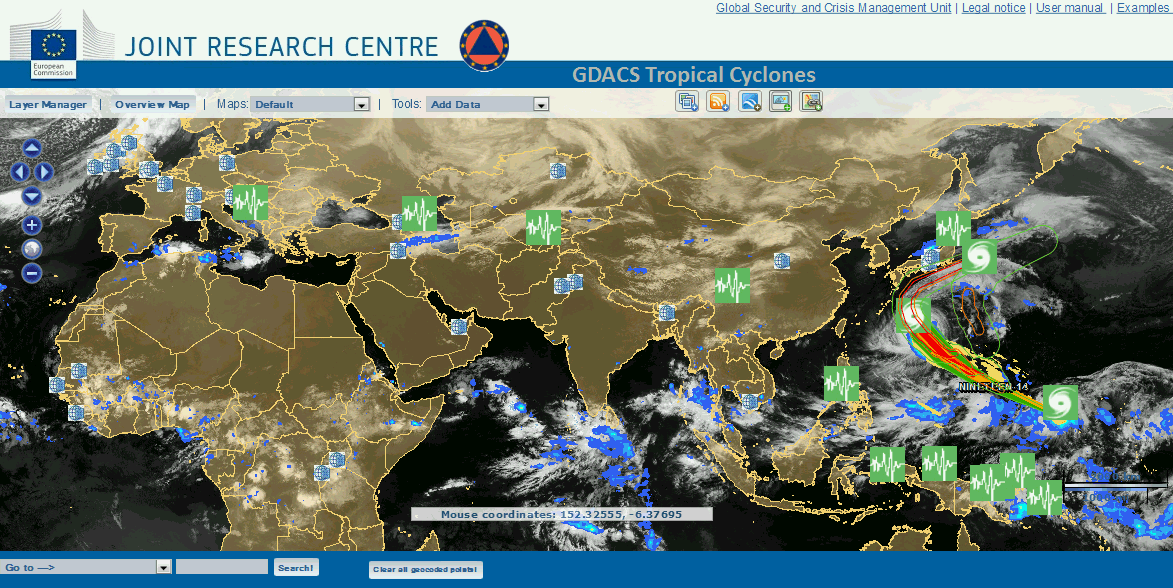
June 12 08:11 UTC 2016
See global satellite cloud image: See concentration at the centre of gravity of the reservoirs behind the world's dams at

See the clouds in the satellite image for India on 11 June 2016 moving towards the centre of gravity of the world's dams:

June 7 05:41 UTC 2016
The peak magnitude earthquake(damquake) for June 2016 is expected between 14 to 20 June with a magnitude of 7.9 MM and the likely candidates for the location are Mexico, The Himalayas, China, Japan, Indonesia, Chile, Peru and the Rift Valley.
May 29 04:27 UTC 2016
A 7.2 MM magnitude damquake occurred on 28 May at South Sandwich Islands:
May 21 13:58 UTC 2016
The Cyclone RAONU(Data IMD)

The cyclone is pointing straight towards the centre of gravity of the world's dams at 24.64,93.99. The world's dams are driving the weather!
See the latest satellite image :

May 20 2016 at 13:49 UTC
The hydrological year 2016-2017
June 12 08:11 UTC 2016
See global satellite cloud image: See concentration at the centre of gravity of the reservoirs behind the world's dams at
| 24.6695 | 94.37985 |

See the clouds in the satellite image for India on 11 June 2016 moving towards the centre of gravity of the world's dams:

June 7 05:41 UTC 2016
The peak magnitude earthquake(damquake) for June 2016 is expected between 14 to 20 June with a magnitude of 7.9 MM and the likely candidates for the location are Mexico, The Himalayas, China, Japan, Indonesia, Chile, Peru and the Rift Valley.
May 29 04:27 UTC 2016
A 7.2 MM magnitude damquake occurred on 28 May at South Sandwich Islands:
| 2016-05-28 09:47:01.2 | 56.27 | S | 27.05 | W | 90 | 7.2 | SOUTH SANDWICH ISLANDS REGION |
May 21 13:58 UTC 2016
The Cyclone RAONU(Data IMD)
The cyclone is pointing straight towards the centre of gravity of the world's dams at 24.64,93.99. The world's dams are driving the weather!
See the latest satellite image :

May 20 2016 at 13:49 UTC
The hydrological year 2016-2017
The hydrological year
June 2016 to May 2017 is being greeted with a cyclone from May 19 2016.
Sri Lanka is
witnessing landslides and flash floods and mudslides.
See the satellite cloud picture:
May 1, 2016 at 16:20 UTC
The peak magnitude damquake for May 2016 is expected to occur between 13 to 20 May 2016 of 7.7 MM moment magnitude.
The likely location is the Himalayas. Because see how the Himalayas have heated up as shown by the UTTARKHAND fires as on 2 May 2016 at 12:32 UTC:

Total number of fires detected : 4258
[ONLY TOP 5 RESULTS ARE SHOWN.]
| Latitude | Longitude | Date | Time | Brightness | Confidence | Scan | Track | Satellite | Version | Bright.T31 | FRP | DayNight |
| 29.751 | 79.553 | 2016-05-01 | 21:25 | 306.7 | nominal | 0.7 | 0.8 | N | 1.0NRT | 283.2 | 0.0 | N |
| 30.212 | 77.902 | 2016-05-01 | 21:25 | 307.6 | nominal | 0.6 | 0.7 | N | 1.0NRT | 295.8 | 0.0 | N |
| 29.757 | 79.558 | 2016-05-01 | 21:25 | 300.2 | nominal | 0.7 | 0.8 | N | 1.0NRT | 281.1 | 0.0 | N |
| 29.764 | 79.532 | 2016-05-01 | 21:25 | 296.1 | nominal | 0.7 | 0.8 | N | 1.0NRT | 272.8 | 0.0 | N |
| 30.229 | 78.038 | 2016-05-01 | 21:25 | 305.8 | nominal | 0.6 | 0.7 | N | 1.0NRT | 294.4 | 0.0 | N |
Simultaneously Fort McMurray in Alberta, Canada was engulfed in flames, 88000 evacuated:
April 24 2016 at 15:17 UTC
The web fire mapper shows hotspots for April 24 a year after the Nepal 7.8 MM damquake:

| 2016-04-16 23:58:37.2 | 0.40 | N | 79.89 | W | 20 | 7.8 | NEAR COAST OF ECUADOR |
April 2 06:55 UTC 2016
Peak Magnitude Earthquake in April 2016: Prediction
7.6 MM major damquake between 14 and 21 April 2016.
Candidates for the location:
The Himalayas, The Pacific Rim, Andaman- Sumatra Bay, Gujarat.
March 2 14:21 UTC 2016
As predicted below a major earthquake has occurred, a little sooner than expected:
| 2016-03-02 12:49:46.9 1hr 33min ago | 4.83 | S | 94.23 | E | 10 | 7.9 | SOUTHWEST OF SUMATRA, INDONESIA |
Re:
http://www.deccanherald.com/content/532212/govt-plans-set-up-more.html
March 1 2016 at 12:17 UTC
The peak magnitude earthquake during March 2016 is expected to be 8.1 MM between 13 to 19 March 2016 and the candidates for location appear to be the Himalayas or the North West Sumatra Region or the Pacific Rim Region, most probably Japan.
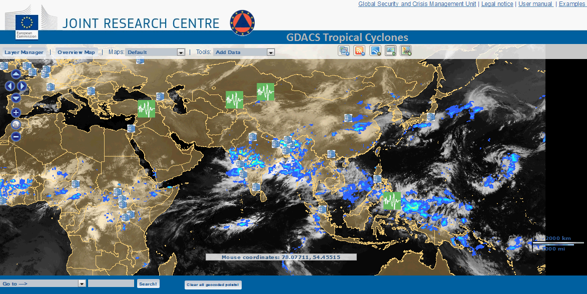
February 19 2016 at 06: 31 UTC
The peaking of hotspots 19 February 2016:

Orissa Andhra Pradesh area Hot spots:
Total
number of fires detected : 1803
[ONLY TOP 5 RESULTS ARE SHOWN.]
[ONLY TOP 5 RESULTS ARE SHOWN.]
Latitude
|
Longitude
|
Date
|
Time
|
Brightness
|
Confidence
|
Scan
|
Track
|
Satellite
|
Version
|
Bright.T31
|
FRP
|
DayNight
|
17.632
|
83.218
|
2016-02-18
|
06:50
|
335.1
|
nominal
|
0.6
|
0.7
|
N
|
1.0NRT
|
305.1
|
0.0
|
D
|
17.638
|
83.217
|
2016-02-18
|
06:50
|
334.0
|
nominal
|
0.6
|
0.7
|
N
|
1.0NRT
|
308.1
|
0.0
|
D
|
17.396
|
82.15
|
2016-02-18
|
06:50
|
331.9
|
nominal
|
0.7
|
0.8
|
N
|
1.0NRT
|
302.3
|
0.0
|
D
|
17.488
|
81.997
|
2016-02-18
|
06:50
|
331.5
|
low
|
0.7
|
0.8
|
N
|
1.0NRT
|
301.9
|
0.0
|
D
|
17.621
|
82.316
|
2016-02-18
|
06:50
|
330.3
|
low
|
0.7
|
0.8
|
N
|
1.0NRT
|
302.0
|
0.0
|
D
|
Myanmar Region
Total
number of fires detected : 3115
[ONLY TOP 5 RESULTS ARE SHOWN.]
[ONLY TOP 5 RESULTS ARE SHOWN.]
Latitude
|
Longitude
|
Date
|
Time
|
Brightness
|
Confidence
|
Scan
|
Track
|
Satellite
|
Version
|
Bright.T31
|
FRP
|
DayNight
|
18.461
|
99.531
|
2016-02-18
|
06:45
|
338.8
|
nominal
|
0.5
|
0.4
|
N
|
1.0NRT
|
304.1
|
0.0
|
D
|
18.308
|
97.923
|
2016-02-18
|
06:45
|
334.2
|
nominal
|
0.4
|
0.4
|
N
|
1.0NRT
|
307.5
|
0.0
|
D
|
18.349
|
97.889
|
2016-02-18
|
06:45
|
336.3
|
nominal
|
0.4
|
0.4
|
N
|
1.0NRT
|
305.4
|
0.0
|
D
|
18.361
|
97.903
|
2016-02-18
|
06:45
|
333.3
|
low
|
0.4
|
0.4
|
N
|
1.0NRT
|
306.5
|
0.0
|
D
|
18.608
|
99.58
|
2016-02-18
|
06:45
|
339.5
|
nominal
|
0.5
|
0.4
|
N
|
1.0NRT
|
307.0
|
0.0
|
D
|
Thailand Laos Vietnam Region
Total number of fires detected : 4305
[ONLY TOP 5 RESULTS ARE SHOWN.]
|
||||||||||||||||||||||||||||||||||||||||||||||||||||||||||||||||||||||||||||||
China Region
Total
number of fires detected : 574
[ONLY TOP 5 RESULTS ARE SHOWN.]
[ONLY TOP 5 RESULTS ARE SHOWN.]
Latitude
|
Longitude
|
Date
|
Time
|
Brightness
|
Confidence
|
Scan
|
Track
|
Satellite
|
Version
|
Bright.T31
|
FRP
|
DayNight
|
24.967
|
114.019
|
2016-02-18
|
05:10
|
339.3
|
nominal
|
0.4
|
0.5
|
N
|
1.0NRT
|
290.5
|
0.0
|
D
|
25.025
|
114.302
|
2016-02-18
|
05:10
|
343.2
|
nominal
|
0.4
|
0.5
|
N
|
1.0NRT
|
289.0
|
0.0
|
D
|
24.966
|
114.019
|
2016-02-18
|
05:10
|
325.9
|
nominal
|
0.4
|
0.5
|
N
|
1.0NRT
|
290.0
|
0.0
|
D
|
24.966
|
114.015
|
2016-02-18
|
05:10
|
338.4
|
nominal
|
0.4
|
0.5
|
N
|
1.0NRT
|
289.2
|
0.0
|
D
|
25.026
|
114.302
|
2016-02-18
|
05:10
|
345.8
|
nominal
|
0.4
|
0.5
|
N
|
1.0NRT
|
289.5
|
0.0
|
D
|
Southern Japan
Total
number of fires detected : 82
[ONLY TOP 5 RESULTS ARE SHOWN.]
[ONLY TOP 5 RESULTS ARE SHOWN.]
Latitude
|
Longitude
|
Date
|
Time
|
Brightness
|
Confidence
|
Scan
|
Track
|
Satellite
|
Version
|
Bright.T31
|
FRP
|
DayNight
|
34.714
|
134.819
|
2016-02-18
|
03:30
|
326.8
|
nominal
|
0.5
|
0.5
|
N
|
1.0NRT
|
289.7
|
0.0
|
D
|
34.491
|
133.714
|
2016-02-18
|
03:30
|
339.5
|
nominal
|
0.5
|
0.5
|
N
|
1.0NRT
|
291.7
|
0.0
|
D
|
34.226
|
132.537
|
2016-02-18
|
03:30
|
336.1
|
nominal
|
0.3
|
0.6
|
N
|
1.0NRT
|
290.3
|
0.0
|
D
|
34.459
|
133.43
|
2016-02-18
|
03:30
|
335.4
|
nominal
|
0.6
|
0.5
|
N
|
1.0NRT
|
288.4
|
0.0
|
D
|
34.47
|
133.433
|
2016-02-18
|
03:30
|
340.6
|
nominal
|
0.6
|
0.5
|
N
|
1.0NRT
|
289.8
|
0.0
|
D
|
TN and Karnataka Region
Total
number of fires detected : 496
[ONLY TOP 5 RESULTS ARE SHOWN.]
[ONLY TOP 5 RESULTS ARE SHOWN.]
Latitude
|
Longitude
|
Date
|
Time
|
Brightness
|
Confidence
|
Scan
|
Track
|
Satellite
|
Version
|
Bright.T31
|
FRP
|
DayNight
|
10.305
|
77.602
|
2016-02-18
|
08:25
|
367.0
|
nominal
|
0.4
|
0.4
|
N
|
1.0NRT
|
296.6
|
0.0
|
D
|
10.305
|
77.599
|
2016-02-18
|
08:25
|
338.2
|
nominal
|
0.4
|
0.4
|
N
|
1.0NRT
|
289.7
|
0.0
|
D
|
10.306
|
77.604
|
2016-02-18
|
08:25
|
344.7
|
nominal
|
0.4
|
0.4
|
N
|
1.0NRT
|
293.1
|
0.0
|
D
|
10.306
|
77.601
|
2016-02-18
|
08:25
|
350.0
|
nominal
|
0.4
|
0.4
|
N
|
1.0NRT
|
296.2
|
0.0
|
D
|
10.305
|
77.598
|
2016-02-18
|
08:25
|
339.2
|
nominal
|
0.4
|
0.4
|
N
|
1.0NRT
|
291.5
|
0.0
|
D
|
Iran Region
Total
number of fires detected : 561
[ONLY TOP 5 RESULTS ARE SHOWN.]
[ONLY TOP 5 RESULTS ARE SHOWN.]
Latitude
|
Longitude
|
Date
|
Time
|
Brightness
|
Confidence
|
Scan
|
Track
|
Satellite
|
Version
|
Bright.T31
|
FRP
|
DayNight
|
27.019
|
49.576
|
2016-02-18
|
10:15
|
344.3
|
nominal
|
0.4
|
0.5
|
N
|
1.0NRT
|
310.4
|
0.0
|
D
|
27.056
|
49.567
|
2016-02-18
|
10:15
|
338.9
|
nominal
|
0.4
|
0.5
|
N
|
1.0NRT
|
305.0
|
0.0
|
D
|
27.101
|
49.311
|
2016-02-18
|
10:15
|
342.9
|
nominal
|
0.4
|
0.5
|
N
|
1.0NRT
|
307.1
|
0.0
|
D
|
28.911
|
47.983
|
2016-02-18
|
10:15
|
336.0
|
low
|
0.6
|
0.4
|
N
|
1.0NRT
|
307.7
|
0.0
|
D
|
28.883
|
47.733
|
2016-02-18
|
10:15
|
348.2
|
nominal
|
0.5
|
0.4
|
N
|
1.0NRT
|
313.7
|
0.0
|
D
|
Africa Central
Total
number of fires detected : 2967
[ONLY TOP 5 RESULTS ARE SHOWN.]
[ONLY TOP 5 RESULTS ARE SHOWN.]
Latitude
|
Longitude
|
Date
|
Time
|
Brightness
|
Confidence
|
Scan
|
Track
|
Satellite
|
Version
|
Bright.T31
|
FRP
|
DayNight
|
9.816
|
17.057
|
2016-02-18
|
00:45
|
307.6
|
nominal
|
0.4
|
0.5
|
N
|
1.0NRT
|
290.9
|
0.0
|
N
|
9.669
|
15.567
|
2016-02-18
|
00:45
|
302.1
|
nominal
|
0.5
|
0.4
|
N
|
1.0NRT
|
288.9
|
0.0
|
N
|
9.787
|
14.467
|
2016-02-18
|
00:45
|
312.2
|
nominal
|
0.5
|
0.4
|
N
|
1.0NRT
|
296.4
|
0.0
|
N
|
9.71
|
14.776
|
2016-02-18
|
00:45
|
314.4
|
nominal
|
0.5
|
0.4
|
N
|
1.0NRT
|
295.1
|
0.0
|
N
|
9.77
|
13.875
|
2016-02-18
|
00:45
|
316.8
|
nominal
|
0.4
|
0.4
|
N
|
1.0NRT
|
298.1
|
0.0
|
N
|
West Central Africa
Total number
of fires detected : 4059
[ONLY TOP 5 RESULTS ARE SHOWN.]
[ONLY TOP 5 RESULTS ARE SHOWN.]
Latitude
|
Longitude
|
Date
|
Time
|
Brightness
|
Confidence
|
Scan
|
Track
|
Satellite
|
Version
|
Bright.T31
|
FRP
|
DayNight
|
12.644
|
-4.682
|
2016-02-18
|
02:25
|
303.6
|
nominal
|
0.3
|
0.6
|
N
|
1.0NRT
|
287.7
|
0.0
|
N
|
12.798
|
-6.538
|
2016-02-18
|
02:25
|
301.0
|
nominal
|
0.5
|
0.5
|
N
|
1.0NRT
|
290.1
|
0.0
|
N
|
12.407
|
-4.791
|
2016-02-18
|
02:25
|
298.3
|
nominal
|
0.3
|
0.6
|
N
|
1.0NRT
|
287.0
|
0.0
|
N
|
12.698
|
-6.659
|
2016-02-18
|
02:25
|
303.2
|
nominal
|
0.5
|
0.5
|
N
|
1.0NRT
|
289.9
|
0.0
|
N
|
12.697
|
-6.654
|
2016-02-18
|
02:25
|
305.2
|
nominal
|
0.5
|
0.5
|
N
|
1.0NRT
|
288.1
|
0.0
|
N
|
West Africa
Total
number of fires detected : 3684
[ONLY TOP 5 RESULTS ARE SHOWN.]
[ONLY TOP 5 RESULTS ARE SHOWN.]
Latitude
|
Longitude
|
Date
|
Time
|
Brightness
|
Confidence
|
Scan
|
Track
|
Satellite
|
Version
|
Bright.T31
|
FRP
|
DayNight
|
14.089
|
-11.173
|
2016-02-18
|
02:25
|
311.8
|
nominal
|
0.4
|
0.4
|
N
|
1.0NRT
|
292.1
|
0.0
|
N
|
14.086
|
-11.178
|
2016-02-18
|
02:25
|
327.6
|
nominal
|
0.4
|
0.4
|
N
|
1.0NRT
|
291.2
|
0.0
|
N
|
14.083
|
-11.504
|
2016-02-18
|
02:25
|
305.3
|
nominal
|
0.4
|
0.4
|
N
|
1.0NRT
|
293.2
|
0.0
|
N
|
13.702
|
-9.535
|
2016-02-18
|
02:25
|
318.4
|
nominal
|
0.5
|
0.4
|
N
|
1.0NRT
|
291.6
|
0.0
|
N
|
13.729
|
-10.261
|
2016-02-18
|
02:25
|
338.5
|
nominal
|
0.4
|
0.4
|
N
|
1.0NRT
|
298.8
|
0.0
|
N
|
North West S America
Total
number of fires detected : 900
[ONLY TOP 5 RESULTS ARE SHOWN.]
[ONLY TOP 5 RESULTS ARE SHOWN.]
Latitude
|
Longitude
|
Date
|
Time
|
Brightness
|
Confidence
|
Scan
|
Track
|
Satellite
|
Version
|
Bright.T31
|
FRP
|
DayNight
|
11.138
|
-72.569
|
2016-02-18
|
05:50
|
308.4
|
nominal
|
0.6
|
0.6
|
N
|
1.0NRT
|
292.4
|
0.0
|
N
|
11.129
|
-72.576
|
2016-02-18
|
05:50
|
305.3
|
nominal
|
0.6
|
0.6
|
N
|
1.0NRT
|
292.7
|
0.0
|
N
|
11.128
|
-72.57
|
2016-02-18
|
05:50
|
305.9
|
nominal
|
0.6
|
0.6
|
N
|
1.0NRT
|
292.8
|
0.0
|
N
|
11.124
|
-72.583
|
2016-02-18
|
05:50
|
332.3
|
nominal
|
0.6
|
0.6
|
N
|
1.0NRT
|
293.4
|
0.0
|
N
|
11.113
|
-72.572
|
2016-02-18
|
05:50
|
307.4
|
nominal
|
0.6
|
0.6
|
N
|
1.0NRT
|
292.4
|
0.0
|
N
|
Florida Panhandle
Total
number of fires detected : 614
[ONLY TOP 5 RESULTS ARE SHOWN.]
[ONLY TOP 5 RESULTS ARE SHOWN.]
Latitude
|
Longitude
|
Date
|
Time
|
Brightness
|
Confidence
|
Scan
|
Track
|
Satellite
|
Version
|
Bright.T31
|
FRP
|
DayNight
|
32.508
|
-80.801
|
2016-02-18
|
07:25
|
310.7
|
nominal
|
0.5
|
0.4
|
N
|
1.0NRT
|
278.4
|
0.0
|
N
|
32.51
|
-80.797
|
2016-02-18
|
07:25
|
296.1
|
nominal
|
0.5
|
0.4
|
N
|
1.0NRT
|
277.9
|
0.0
|
N
|
32.509
|
-80.793
|
2016-02-18
|
07:25
|
296.1
|
nominal
|
0.5
|
0.4
|
N
|
1.0NRT
|
277.9
|
0.0
|
N
|
32.507
|
-80.803
|
2016-02-18
|
07:25
|
299.3
|
nominal
|
0.5
|
0.4
|
N
|
1.0NRT
|
278.8
|
0.0
|
N
|
32.456
|
-81.6
|
2016-02-18
|
07:25
|
327.4
|
nominal
|
0.4
|
0.4
|
N
|
1.0NRT
|
278.2
|
0.0
|
N
|
A major earthquake as predicted is imminent in the next
days.
February 7 2016 at 0804 UTC
There was a deadly strong magnitude damquake of 6.4 MM at Taiwan on 5th February 2016:
| 2016-02-05 19:57:27.1 | 22.93 | N | 120.54 | E | 17 | 6.4 | TAIWAN |
Look at the number of hotspots in the world past 24 hrs on 1 to 6 February 2016, and at the quake location at the designated times, all UTC:
6 17394 at 15:03:21 Taiwan 24:00 5
5 9131 at 12:56:18 Taiwan 24:00 0 Quake at 19:57
4 18518 at 14:56:54 Taiwan 24:00 0
3 10107 at 13:05:11 Taiwan 24:00 2
2 15088 at 14:04:20 Taiwan 24:00 0
1 10175 at 12:46:37 Taiwan 24:00 0
This is sequence for all the quakes caused by dams, samples of which have been analysed in this running narrative! See the proof that dams of the world are causing these quakes at
http://predictingquakes.blogspot.in/2015/04/the-science-of-dams-causing-earthquakes.html
If you dear reader check out this and decide for yourself one way or the other, leave a comment so life may be saved. It may be too late for India as my research shows that one scenario like that of the atmospheric nuclear tests results in the killing of all babies born in 2028-2029 by nuclear contamination caused by the Fukushima extinction breeding event caused by the dams(ten times that caused by the tests).
See
http://glaringlacuna.blogspot.in/2012/01/nuclear-effect-in-causing-earthquakes.html
The implication for prediction of an impending damquake is to watch out when the number of hotspots caused by the direct heating up of the earth by the world's dams registers a steep fall from a steep total.
Read these dam related events in modern civilization:
It is not necessary that a dam
surge always results in a damquake. A dam related event like a landslide or
damage to a structure may occur. Thus on 4 February 2016 at 15:05 UTC
Kudankulam Nuclear Unit 1(8.17,77.7) suffered a steam leak and was shut down for detailed inspection.
This occurred when a dam surge caused by the world’s dams was passing from a
damquake at 15:01:13 UTC at location 36.186, -91.375 at 4.2 km depth in
Arkansas to another damquake which occurred at 15:06:36.1 UTC at location
50.33, 18.95 at 1 km depth of magnitude 2.8 MM in Poland. Nuclear reactor No2 at the Salem Nuclear Power
Plant at New Jersey(39.0128,-75.536) suffered an automatic reactor trip due to main turbine
trip, also on 4 February 2016 at 16:21 UTC. See the event notification text:
Unit
|
SCRAM Code
|
RX CRIT
|
Initial PWR
|
Initial RX Mode
|
Current PWR
|
Current RX Mode
|
2
|
A/R
|
Y
|
74
|
Power Operation
|
0
|
Hot Standby
|
Event
Text
AUTOMATIC
REACTOR TRIP DUE TO MAIN TURBINE TRIP
"This 4 and 8 hour notification is being made to report that Salem Unit 2 suffered an unplanned automatic reactor trip and subsequent automatic Auxiliary Feedwater system actuation. The trip was initiated due to a Main Turbine trip above P-9 (49% power). The Main Turbine trip was caused by a Main Generator Protection signal. "Salem Unit 2 is currently stable in Mode 3. Reactor Coolant system pressure is 2235 PSIG and Reactor Coolant system temperature is 547 F with decay heat removal via the Main Steam Dump and Auxiliary Feedwater Systems. Unit 2 has no active shutdown tech spec action statements in effect. All control rods inserted on the reactor trip. All ECCS and ESF systems functioned as expected. "No major secondary equipment was tagged for maintenance prior to this event. The 24 Service Water pump is tagged for scheduled preventive maintenance and did not affect post trip plant response. No personnel were injured during this event." The licensee has notified the NRC Resident Inspector and will notify the Lower Alloway Creek Township. |
Further Indian Point Nuclear Station
at Buchanan in New York(41.2697,-73.952) suffered a massive tritium leak into
groundwater according to a report received on 5th February 2016, the
event probably occurred thus on 4th February 2016 as well. Description derived from enenews and newsreports:
http://enenews.com/govt-radiation-leak-nuclear-plant-major-city-alarming-levels-radioactivity-65000-spike-detected-official-deeply-concerned-significant-failure-expert-radiation-protection-being-sent-site-video/comment-page-1#comments
AP, Feb 6, 2016: It was unclear how much
water spilled, but samples showed the water had a radioactivity level of more
than 8 million picocuries per liter… The levels are the highest
regulators have seen at Indian Point… Contaminated groundwater would
likely slowly make its way to the Hudson River, [an NRC
spokesman] said… Tritium [is] a radioactive form of hydrogen that poses the greatest
risk of causing cancer when it ends up in drinking water.http://enenews.com/govt-radiation-leak-nuclear-plant-major-city-alarming-levels-radioactivity-65000-spike-detected-official-deeply-concerned-significant-failure-expert-radiation-protection-being-sent-site-video/comment-page-1#comments
Gov. Andrew Cuomo, Feb 6, 2016: “Yesterday I learned that radioactive tritium-contaminated water leaked… The company reported alarming levels of radioactivity at three monitoring wells, with one well’s radioactivity increasing nearly 65,000 percent.”
Gov. Cuomo’s letter to Commissioner Zucker (Dept. of Health) & Acting Commissioner Seggos (Dept. of Environmental Conservation), Feb 6, 2016: “I am deeply concerned… Indian Point has experienced significant failure in its operation and maintenance… levels of radioactivity reported this week are significantly higher than in past incidents… Our first concern is for the health and safety of the residents… I am directing you to fully investigate this incident… to determine the extent of the release, its likely duration, its causes, its potential impacts to the environment and public health, and how the release can be contained.”
Ellen Jaffee, New York Assemblymember, Feb 6, 2016: “I am concerned about the alarming increase in radioactive water leaking… My primary concern is the potential impact this… may have on public health and our environment.”
CBS 6 Albany transcript, Feb 6, 2016: “[The NRC] says that exposure to high levels of tritium may cause cancer in humans or genetic defects.”
And then there is the landslide which
occurred at Siachen glacier(35.4639,77.0439) on 3 February 2016, which killed
ten armymen in India.
February 4 2016 at 558 UTC
Peak Magnitude Damquake for February 2016
See
https://blogger.googleusercontent.com/img/b/R29vZ2xl/AVvXsEh-pK3GMtRl8MXO2aR5VHeoxrNwSp5-kPNgnVNsanmeVY2oZdIG2alnkMNDjCvuE74s1gnOaPtk5Sa5xIehqebkvUdnZtz_hwNtoml4YI44h_FQRt3nj4RtTFurDEFqsaacW2Fzsw/s1600-h/image004.gif
A peak magnitude damquake is expected in the range 6.9 to 7.6 MM between 12 to 18 February.
The expected location is one of the Himalayas, Maharashtra, Bihar or the North East of India or Myanmar or China or Indonesia or Vietnam or Japan or the Pacific Rim region.
See the hotspot map:

January 24, 1331 UTC 2016
As expected a 7.1 MM magnitude major damquake occurred in Alaska:
Note that the estimated location included the Rift Valley which has a longitude band of 25. And the location was 180-25 or 155 or Alaska a supplementary to Rift Valley.
January 4, 12:19 UTC, 2016.
Prediction of the Peak Magnitude Earthquake for January 2016
See https://blogger.googleusercontent.com/img/b/R29vZ2xl/AVvXsEh-pK3GMtRl8MXO2aR5VHeoxrNwSp5-kPNgnVNsanmeVY2oZdIG2alnkMNDjCvuE74s1gnOaPtk5Sa5xIehqebkvUdnZtz_hwNtoml4YI44h_FQRt3nj4RtTFurDEFqsaacW2Fzsw/s1600-h/image004.gif
7.1 to 7.7 MM between 11 to 17 January 2016.
Expected candidates for the location of the peak magnitude damquake:
Western Turkey or Rift Valley or The Himalayas or Andaman Sumatra Bay or Indonesia or China/Taiwan or Japan or New Zealand.
December 3 to 7, 2015
The peak magnitude damquake for December 2015 is
7.1 to 8.7 MM between 9 and 16 December 2015.
Brazil is the expected location(maximum number of hotspots as seen in Web Fire Mapper of 3 December 2015 at 0700 UTC) or Tamilnadu coast or Andaman Sumatra Bay or Japan. Looking at the dam dynamics today 7 December 2015, which saw a major fire in Kandivali slum(Latitude = 19.2009, Longitude = 72.8771) and a major dam quake in Tajikistan:
| 2015-12-07 07:50:07.2 6hr 10min ago | 38.18 | N | 72.91 | E | 30 | 7.2 | TAJIKISTAN |
http://trmm.gsfc.nasa.gov/trmm_rain/Events/latest_big_3hrly.gif
and
http://trmm.gsfc.nasa.gov/trmm_rain/Events/big_global_accumlation.gif
30 November 2015 at 0519 UTC
So far in the Month of November there were two major deep focus earthquakes of magnitude 7.6 in Peru and Brazil:
The prediction was for a major earthquake between 7.2 to 7.9 MM between 14 to 21 November and in the 70-75 longitude band or as shown previously in the -70 to -75 longitude band. The deep focus quake occurred in the latter band. But November is still not over so we may expect a major shallow quake still in South America or Japan or on the Pacific Rim or the Himalayas or the Andaman Nicobar Isles Region.
M 7.6 - 169km WNW of Iberia, Peru
- Time
- Location
- 10.548°S 70.904°W
- Depth
- 600.6 km
M 7.6 - 210km S of Tarauaca, Brazil
- Time
- Location
- 10.047°S 71.023°W
- Depth
- 611.7 km
31 October 2015 at 23:39 UTC
The total number of hotspots as shown by web fire mapper is 5394 during past 24 hrs ended at 10:16:57 and about 50% is concentrated in North India:
Total number of fires detected : 2386
[ONLY TOP 5 RESULTS ARE SHOWN.]
| Latitude | Longitude | Date | Time | Brightness | Confidence | Scan | Track | Satellite | Version | Bright.T31 | FRP |
| 30.404 | 76.315 | 2015-10-29 | 08:30 | 323.1 | 76 | 1.5 | 1.2 | A | 5.0 | 298.4 | 32.1 |
| 30.255 | 74.959 | 2015-10-29 | 08:30 | 311.2 | 47 | 1.3 | 1.1 | A | 5.0 | 300.2 | 7.7 |
| 30.172 | 74.259 | 2015-10-29 | 08:30 | 325.1 | 78 | 1.2 | 1.1 | A | 5.0 | 302.1 | 26.2 |
| 30.066 | 73.26 | 2015-10-29 | 08:30 | 328.1 | 81 | 1.1 | 1.0 | A | 5.0 | 303.8 | 25.6 |
| 30.434 | 76.184 | 2015-10-29 | 08:30 | 313.4 | 58 | 1.5 | 1.2 | A | 5.0 | 298.8 | 16.0 |
So hereabouts or in the Himalayas we may expect the peak magnitude damquake for November 2015:
Peak Magnitude: 7.2 to 7.9 MM between 14th to 21st November 2015.
There has been a deep focus damquake in Western Honshu Region:
| Magnitude | mb 4.6 |
| Region | WESTERN HONSHU, JAPAN |
| Date time | 2015-10-31 06:49:10.3 UTC |
| Location | 35.83 N ; 135.39 E |
| Depth | 365 km |
| Distances | 96 km N of Kyoto, Japan / pop: 1,459,640 / local time: 15:49:10.3 2015-10-31
38 km NE of Miyazu, Japan / pop: 21,632 / local time: 15:49:10.3 2015-10-31 |
Total number of fires detected : 1
[ONLY TOP 5 RESULTS ARE SHOWN.]
| Latitude | Longitude | Date | Time | Brightness | Confidence | Scan | Track | Satellite | Version | Bright.T31 | FRP |
| 34.461 | 133.434 | 2015-10-31 | 17:00 | 308.3 | 60 | 1.0 | 1.0 | A | 5.0 | 282.9 | 18.1 |
Throughout the 130-135 longitude band we see intense hotspots:
Total number of fires detected : 358
[ONLY TOP 5 RESULTS ARE SHOWN.]
| Latitude | Longitude | Date | Time | Brightness | Confidence | Scan | Track | Satellite | Version | Bright.T31 | FRP |
| 46.98 | 131.435 | 2015-10-29 | 01:55 | 315.1 | 59 | 1.5 | 1.2 | T | 5.0 | 271.4 | 44.5 |
| 46.929 | 131.238 | 2015-10-29 | 01:55 | 327.7 | 76 | 1.5 | 1.2 | T | 5.0 | 269.9 | 70.8 |
| 46.907 | 131.475 | 2015-10-29 | 01:55 | 313.8 | 59 | 1.5 | 1.2 | T | 5.0 | 270.4 | 45.2 |
| 45.01 | 131.435 | 2015-10-29 | 01:55 | 318.3 | 69 | 1.4 | 1.2 | T | 5.0 | 273.7 | 49.8 |
| 44.71 | 132.813 | 2015-10-29 | 01:55 | 351.6 | 96 | 1.2 | 1.1 | T | 5.0 | 278.1 | 109.1 |
Total number of fires detected : 551
[ONLY TOP 5 RESULTS ARE SHOWN.]
| Latitude | Longitude | Date | Time | Brightness | Confidence | Scan | Track | Satellite | Version | Bright.T31 | FRP |
| -12.579 | 136.588 | 2015-10-29 | 00:30 | 320.6 | 67 | 4.7 | 2.0 | T | 5.0 | 299.8 | 75.3 |
| -12.587 | 136.63 | 2015-10-29 | 00:30 | 326.2 | 79 | 4.7 | 2.0 | T | 5.0 | 299.9 | 144.0 |
| -12.586 | 136.625 | 2015-10-29 | 00:30 | 328.1 | 81 | 4.7 | 2.0 | T | 5.0 | 299.9 | 172.2 |
| -11.83 | 133.138 | 2015-10-29 | 02:10 | 316.3 | 38 | 4.3 | 1.9 | T | 5.0 | 296.9 | 40.1 |
| -12.266 | 132.822 | 2015-10-29 | 02:10 | 328.8 | 33 | 4.1 | 1.9 | T | 5.0 | 304.2 | 95.6 |
Total number of fires detected : 671
[ONLY TOP 5 RESULTS ARE SHOWN.]
| Latitude | Longitude | Date | Time | Brightness | Confidence | Scan | Track | Satellite | Version | Bright.T31 | FRP |
| -18.383 | 132.348 | 2015-10-29 | 02:10 | 342.2 | 62 | 4.5 | 2.0 | T | 5.0 | 289.3 | 431.7 |
| -18.436 | 132.338 | 2015-10-29 | 02:10 | 315.2 | 0 | 4.5 | 2.0 | T | 5.0 | 276.2 | 119.5 |
| -18.628 | 132.484 | 2015-10-29 | 02:10 | 334.4 | 66 | 4.7 | 2.0 | T | 5.0 | 296.2 | 244.0 |
| -19.596 | 132.289 | 2015-10-29 | 02:10 | 334.2 | 86 | 4.6 | 2.0 | T | 5.0 | 300.6 | 223.3 |
| -19.6 | 132.334 | 2015-10-29 | 02:10 | 322.7 | 58 | 4.7 | 2.0 | T | 5.0 | 297.7 | 83.2 |
So we may expect a major damquake or a dam related damage causing event in this longitude band, say in Japan or Indonesia.
26 October 2015 at 13:35 UTC
A major damquake has occurred as predicted by me:
| 2015-10-26 09:09:32.9 | 4hr 21min ago | 36.49 | N | 70.94 | E | 215 | 7.5 | HINDU KUSH REGION, AFGHANISTAN |
As is always the case a deep focus damquake preceded this:
| 2015-10-26 01:41:32.5 | 25.25 | S | 178.81 | E | 560 | 5.1 | SOUTH OF FIJI ISLANDS |
The earthquake map:
Initial newsreport:
180 killed.Revised: 230 killed(27 October 2015).
http://www.cnn.com/2015/10/26/asia/afghanistan-earthquake/index.html
How they felt it:
http://earthquake.usgs.gov/earthquakes/eventpage/us10003re5#impact_dyfi
Another newsreport:
http://www.deccanherald.com/content/508386/over-130-dead-pakistan-quake.html
Later newsreport:
http://www.deccanherald.com/content/508477/over-230-killed-pak-af.html
25 October 2015 at 21:32 UTC
Huge conglomerations of hotspots in Brazil, Madagascar, North India, Indonesia, South East Russia of thousands of hotspots. The dams are creating havoc! Dam related events like Patricia Hurricane's effects, earthquakes and volcanoes may occur in the coming days and weeks.
The hotspots:
The hotspots during 23 to 25 October 2015:
Brazil:
Total number of fires detected : 1681
[ONLY TOP 5 RESULTS ARE SHOWN.]
| Latitude | Longitude | Date | Time | Brightness | Confidence | Scan | Track | Satellite | Version | Bright.T31 | FRP |
| -7.478 | -46.689 | 2015-10-23 | 01:50 | 315.7 | 89 | 1.3 | 1.1 | T | 5.0 | 295.3 | 21.8 |
| -7.48 | -46.701 | 2015-10-23 | 01:50 | 313.5 | 82 | 1.3 | 1.1 | T | 5.0 | 295.0 | 18.5 |
| -7.468 | -46.691 | 2015-10-23 | 01:50 | 306.4 | 45 | 1.3 | 1.1 | T | 5.0 | 294.7 | 9.6 |
| -7.47 | -46.702 | 2015-10-23 | 01:50 | 307.4 | 54 | 1.3 | 1.1 | T | 5.0 | 294.5 | 11.0 |
| -6.887 | -44.542 | 2015-10-23 | 01:50 | 307.0 | 51 | 1.8 | 1.3 | T | 5.0 | 296.4 | 15.3 |
Madagascar:
Total number of fires detected : 1873
[ONLY TOP 5 RESULTS ARE SHOWN.]
| Latitude | Longitude | Date | Time | Brightness | Confidence | Scan | Track | Satellite | Version | Bright.T31 | FRP |
| -15.201 | 47.874 | 2015-10-23 | 07:45 | 331.9 | 84 | 3.4 | 1.7 | T | 5.0 | 302.6 | 105.2 |
| -15.211 | 47.867 | 2015-10-23 | 07:45 | 329.0 | 63 | 3.4 | 1.7 | T | 5.0 | 301.9 | 77.1 |
| -15.531 | 48.117 | 2015-10-23 | 07:45 | 319.5 | 55 | 3.6 | 1.8 | T | 5.0 | 300.2 | 53.3 |
| -15.523 | 48.111 | 2015-10-23 | 07:45 | 324.4 | 78 | 3.6 | 1.8 | T | 5.0 | 300.7 | 91.9 |
| -16.136 | 47.181 | 2015-10-23 | 07:45 | 320.6 | 65 | 3.1 | 1.7 | T | 5.0 | 303.8 | 62.4 |
North India:
Total number of fires detected : 1068
[ONLY TOP 5 RESULTS ARE SHOWN.]
| Latitude | Longitude | Date | Time | Brightness | Confidence | Scan | Track | Satellite | Version | Bright.T31 | FRP |
| 31.133 | 75.295 | 2015-10-23 | 05:50 | 318.5 | 70 | 1.0 | 1.0 | T | 5.0 | 305.6 | 9.8 |
| 31.094 | 75.544 | 2015-10-23 | 05:50 | 315.0 | 63 | 1.1 | 1.0 | T | 5.0 | 301.1 | 9.8 |
| 31.127 | 75.222 | 2015-10-23 | 05:50 | 317.9 | 69 | 1.0 | 1.0 | T | 5.0 | 303.4 | 11.1 |
| 31.113 | 75.197 | 2015-10-23 | 05:50 | 316.8 | 67 | 1.0 | 1.0 | T | 5.0 | 302.9 | 10.1 |
| 31.089 | 75.17 | 2015-10-23 | 05:50 | 314.4 | 59 | 1.0 | 1.0 | T | 5.0 | 301.7 | 7.2 |
Indonesia:
Total number of fires detected : 2708
[ONLY TOP 5 RESULTS ARE SHOWN.]
| Latitude | Longitude | Date | Time | Brightness | Confidence | Scan | Track | Satellite | Version | Bright.T31 | FRP |
| -3.125 | 112.583 | 2015-10-23 | 02:45 | 331.7 | 24 | 1.3 | 1.1 | T | 5.0 | 307.9 | 25.7 |
| -3.148 | 112.737 | 2015-10-23 | 02:45 | 345.2 | 93 | 1.2 | 1.1 | T | 5.0 | 304.2 | 59.2 |
| -3.117 | 112.521 | 2015-10-23 | 02:45 | 328.9 | 75 | 1.3 | 1.1 | T | 5.0 | 304.1 | 28.7 |
| -3.149 | 112.731 | 2015-10-23 | 02:45 | 336.0 | 80 | 1.2 | 1.1 | T | 5.0 | 304.5 | 35.4 |
| -3.15 | 112.742 | 2015-10-23 | 02:45 | 329.7 | 42 | 1.2 | 1.1 | T | 5.0 | 302.8 | 25.0 |
Papua Region:
Total number of fires detected : 1185
[ONLY TOP 5 RESULTS ARE SHOWN.]
| Latitude | Longitude | Date | Time | Brightness | Confidence | Scan | Track | Satellite | Version | Bright.T31 | FRP |
| -4.635 | 144.674 | 2015-10-23 | 01:05 | 316.6 | 38 | 1.6 | 1.3 | T | 5.0 | 300.6 | 17.1 |
| -4.307 | 142.395 | 2015-10-23 | 01:05 | 313.8 | 59 | 1.2 | 1.1 | T | 5.0 | 297.9 | 10.3 |
| -4.304 | 142.311 | 2015-10-23 | 01:05 | 313.7 | 45 | 1.1 | 1.1 | T | 5.0 | 298.2 | 9.5 |
| -4.634 | 144.669 | 2015-10-23 | 01:05 | 319.8 | 72 | 1.6 | 1.3 | T | 5.0 | 301.4 | 26.3 |
| -4.645 | 144.667 | 2015-10-23 | 01:05 | 315.1 | 50 | 1.6 | 1.3 | T | 5.0 | 299.4 | 14.7 |
East Russia Region
Total number of fires detected : 1093
[ONLY TOP 5 RESULTS ARE SHOWN.]
| Latitude | Longitude | Date | Time | Brightness | Confidence | Scan | Track | Satellite | Version | Bright.T31 | FRP |
| 48.112 | 124.888 | 2015-10-23 | 02:30 | 312.6 | 55 | 1.2 | 1.1 | T | 5.0 | 289.0 | 20.8 |
| 52.109 | 126.195 | 2015-10-23 | 02:30 | 320.7 | 73 | 1.2 | 1.1 | T | 5.0 | 276.0 | 39.9 |
| 52.088 | 126.207 | 2015-10-23 | 02:30 | 339.6 | 69 | 1.2 | 1.1 | T | 5.0 | 278.9 | 72.5 |
| 52.086 | 126.224 | 2015-10-23 | 02:30 | 327.8 | 31 | 1.2 | 1.1 | T | 5.0 | 277.3 | 47.5 |
| 48.81 | 125.112 | 2015-10-23 | 02:30 | 316.5 | 66 | 1.2 | 1.1 | T | 5.0 | 288.6 | 26.3 |
Total number of fires detected : 2332
[ONLY TOP 5 RESULTS ARE SHOWN.]
| Latitude | Longitude | Date | Time | Brightness | Confidence | Scan | Track | Satellite | Version | Bright.T31 | FRP |
| 47.118 | 131.665 | 2015-10-23 | 02:30 | 316.9 | 25 | 1.1 | 1.1 | T | 5.0 | 286.3 | 20.0 |
| 44.076 | 131.887 | 2015-10-23 | 02:30 | 321.0 | 73 | 1.3 | 1.1 | T | 5.0 | 289.0 | 38.9 |
| 43.962 | 131.992 | 2015-10-23 | 02:30 | 318.0 | 69 | 1.3 | 1.1 | T | 5.0 | 289.5 | 33.8 |
| 43.959 | 132.008 | 2015-10-23 | 02:30 | 310.3 | 36 | 1.3 | 1.1 | T | 5.0 | 289.6 | 21.6 |
| 48.024 | 132.722 | 2015-10-23 | 02:30 | 341.1 | 90 | 1.2 | 1.1 | T | 5.0 | 286.9 | 75.9 |
Remark on 27 October 2015:
Damquake had occurred in Pakistan on 23 October 2015, a precursor to a major quake in the Hindukush mountains on 26th October 2015.:
| 23/10/2015 | 00:27:39 | 29.7°N | 70.4°E | 25.0 | 5.6 | PAKISTAN |
21 October 2015 at 02:26 UTC
Near Indonesia at Vanuatu a major earthquake occurred as predicted by me:
| 2015-10-20 21:52:03.4 4hr 30min ago | 14.88 | S | 167.33 | E | 147 | 7.1 | VANUATU |
14 October 2015 at 18:23 UTC
The Web Fire Mapper for 12 to 14 October reveals hotspot clusters in Brazil Region, Southern Africa including Madagascar, Indonesia including the Papua Region of thousands of hotspots in each region. The number of hotspots in the world on 14 October noon 2015 registered 17465 while on the previous day 13 October about noon 2015 it was 9203! This is in line with prediction of 30 Sep 2015 at 1650 UTC(See below).
30 Sep 2015 at 1650 UTC
Prediction of peak magnitude earthquake for October 2015
7.8 MM between 15th to 21 October 2015.
Likely locations: S. America or Africa(Rift Valley), Indonesia, the Himalayas or China or Japan or in the region around Lat 48,Long 40.
17 Sep 2015 7:09:31 UTC
As much more than predicted, a great 8.3 MM earthquake occurred off Chile Coast on 16 September 2015 triggering tsunami:
| 2015-09-16 22:54:33.0 8hr 18min ago | 31.57 | S | 71.58 | W | 30 | 8.3 | OFFSHORE COQUIMBO, CHILE |
See newsreport:
http://www.theguardian.com/world/live/2015/sep/17/chile-earthquake-massive-83-magnitude-tremor-strikes-santiago-live-updates
I saw this coming when I noticed enormous number of hotspots in South America yesterday:
2015-09-12 0530 UTC
The peak magnitude earthquake prediction for September 2015 is as follows:
Dam caused and expected between 12th to 18 September 2015 with a magnitude of 7.9 MM in Japan or Indonesia or China or elsewhere on the Pacific Rim or in the Himalayas or in the Turkey Region. Of course a dam related event(flash floods and landslides) is ravaging Japan and threatening its nuclear plants and causing radioactive contamination of the Pacific right now. See enenews:
Latest Headlines:
2015-08-13 at 13:34 UTC
The number of hotspots in the past 24 hours detected by the web fire mapper(NASA) on 12 August 2015 at 09:14: 27 UTC : 24294
The number of hotspots in the past 24 hours detected by the web fire mapper(NASA) on 13 August 2015 at 09:07: 21 UTC : 5844
At 14:50 UTC on 12 August 2015 there was fire followed by massive explosions in the Port City of Tianjin, China,
39.0842,117.2010, in which 54 people were killed and hundreds injured. Is this the disaster portent of the drastic reduction in the number of hotspots observed from 12 to13 August 2015 or a major earthquake is indicated? See Prediction below.
Latest News 2015-08-04 12:22 UTC
Prediction of the peak magnitude earthquake for August 2015
See
https://blogger.googleusercontent.com/img/b/R29vZ2xl/AVvXsEh-pK3GMtRl8MXO2aR5VHeoxrNwSp5-kPNgnVNsanmeVY2oZdIG2alnkMNDjCvuE74s1gnOaPtk5Sa5xIehqebkvUdnZtz_hwNtoml4YI44h_FQRt3nj4RtTFurDEFqsaacW2Fzsw/s1600-h/image004.gif
It is expected to be 7.3 to 7.7 MM magnitude to occur between 14 to 20 August 2015 in the Pacific Rim probably in China or Japan or in Turkey or in the Himalayas or in the Rift Valley Region of Africa.
Modern civilization's dams are also causing its self destruction! The latest: The Himalayan earthquake in Nepal
The dance of the earthquakes around Chernobyl is identical and synchronous to the dance of those around Lumjung, Nepal and to the dance of worldwide earthquakes: 41 year study from 19730601 to 20140531. The dances are determined by the World's dams. The story is the same for all disasters wrought by modern civilization, be it the Air France 447 crash in a thunderstorm or the Air Asia crash in a thunderstorm, the Fukushima China syndrome triple core melt or many more to come.
Modern civilization also wrought with the Nepal damquake a huge number of avalanches on Mt Everest killing many climbers including sherpas.
The actors of modern civilization do not recognise that this is one more disaster of self destruction of modern civilization. Its not the plates, its the dams that are wreaking havoc in the Himalayas. The height of Mt Everest is about 8.9 km. The water pressure head change of the world's dams that was exerted at the centre of gravity of the dams is about 77 million km! And the power of the Water moment exerted by the dams on Mt Everest is about 100000 terawatts equivalent to that of an 8.1 MM moment magnitude great earthquake. See Table below. In 2013 June it was the dams exerting their surges on Mt Kedarnath! In 2015 April its the Mt Everest that bore the brunt of the surges of the world's dams.
In living in this world by his own will and skill, the stupidest peasant or tribesman is more competent than the most intelligent worker or technician or intellectual ina society of specialists (that is modern civilization) - Wendell Berry in the Unsettling of America, Culture and Agriculture.
In 1908, Mahatma Gandhi took one look at this evil and proclaimed: Given enough time modern civilization will destroy itself. He also said: The East can meet the West when the West throws overboard almost the whole of modern civilization(mc). The East also can meet the West when the East embraces mc. But that will be an armed truce with mutual assurance of self destruction.
See http://predictingquakes.blogspot.in/2015/04/the-science-of-dams-causing-earthquakes.html
LATEST NEWS
25 APRIL 2015 0908 UTC
The peak magnitude earthquake predicted for April 2015 is available at:
https://blogger.googleusercontent.com/img/b/R29vZ2xl/AVvXsEh-pK3GMtRl8MXO2aR5VHeoxrNwSp5-kPNgnVNsanmeVY2oZdIG2alnkMNDjCvuE74s1gnOaPtk5Sa5xIehqebkvUdnZtz_hwNtoml4YI44h_FQRt3nj4RtTFurDEFqsaacW2Fzsw/s1600-h/image004.gif
Peak 7 to 7.6 MM between 14 to 21 April 2015.
Actually a peak magnitude earthquake measuring 7.9 MM occurred in Nepal:
If we draw a 200 km radius circle centered at Lumjung, Nepal and study the earthquakes in this circle, we find that these earthquakes are determined by the dam surges and dance synchronously with those worldwide. The region's earthquakes and the Worldwide earthquakes in a given period correlate extremely significantly with the total worldwide dam content changes in the corresponding period. See for example the study for the period 19730601 to 20140531 conducted for the Chernobyl Region and the World at:
http://glaringlacuna.blogspot.in/2013/04/the-chernobyl-disaster-worlds-dam.html
The Lumjung 7.8 MM earthquake data
The correlation of the annual mean number of earthquakes 200 km around the Location of the Lumjung quake with a) Annual Dam Capacity World is 0.867, df 39, p 2.22E -13; b) Cumulative Sum of Annual Dam Content Changes of the World is 0.861,df 39, p 5.25E-13. The corresponding figures for the World's Quakes are 0.962,df 39, p 1.13E-23 and 0.949,df 39, p 3.28E-21 respectively.
Now have a look at the dance:
Now see the synchrony of the Chernobyl quake dance with the Nepalese earthquake dance:
THE MAJOR LUMJUNG NEPAL 25 APRIL 2015 DAMQUAKE
15 JANUARY 2015 7:04 UTC
Peak Magnitude Earthquake expected for January 2015:
7.1 to 7.7 MM between 11 to 17 January 2015. Most probably in Iceland or the Pacific Rim or the Himalayas or Indoneasia near Banda Aceh.
2 DECEMBER 2014 6:09 UTC
Prediction for the peak magnitude damquake during December 2014
Location : Pacific Rim or Iran or Turkey or the Himalayas or Alaska
15 NOVEMBER 2014 4:47 UTC
A major damquake occurred in the Pacific Rim Area as predicted by me(See update for 2 November 2014):
| 2014-11-15 02:31:43.4 | 1.92 | N | 126.50 | E | 52 | 7.2 | MOLUCCA SEA |
See newsreport:
http://www.thehindu.com/news/international/world/quake-hits-indonesia-waters-tsunami-possible/article6601810.ece?homepage=true
The Pacific Tsunami Warning Centre said the quake could cause hazardous tsunami waves within 300 km of the epicentre along the nearby coasts of Indonesia and the southern Philippines.
This was preceded by a deep focus damquake ten hours earlier in the same region:
| 2014-11-14 16:58:59.6 | 7.57 | S | 119.87 | E | 450 | 4.5 | FLORES SEA |
9 NOVEMBER 2014 5:07 UTC
Iceland was devoid of hotspots on 5th, 6th and 7th November 2014 but hotspots appeared bright and with 100 confidence on the 8th:
Total number of fires detected : 9
[ONLY TOP 5 RESULTS ARE SHOWN.]
| Latitude | Longitude | Date | Time | Brightness | Confidence | Scan | Track | Satellite | Version | Bright.T31 | FRP |
| 64.878 | -16.83 | 2014-11-08 | 12:50 | 411.2 | 100 | 1.0 | 1.0 | T | 5.0 | 271.9 | 0.0 |
| 64.874 | -16.81 | 2014-11-08 | 12:50 | 500.0 | 100 | 1.0 | 1.0 | T | 5.0 | 335.7 | 0.0 |
| 64.871 | -16.79 | 2014-11-08 | 12:50 | 500.0 | 100 | 1.0 | 1.0 | T | 5.0 | 323.3 | 0.0 |
| 64.868 | -16.77 | 2014-11-08 | 12:50 | 457.1 | 100 | 1.0 | 1.0 | T | 5.0 | 295.9 | 0.0 |
| 64.865 | -16.75 | 2014-11-08 | 12:50 | 400.2 | 100 | 1.0 | 1.0 | T | 5.0 | 280.8 | 0.0 |
Watch out for a dam related event soon.
7 NOVEMBER 2014 7:21 UTC
The hotspots in Iceland remain nil both on the 5th and 6th of November 2014. However damquakes are occurring.
| 2014-11-06 18:26:34.5 | 64.51 | N | 17.56 | W | 10 | 4.6 | ICELAND |
| 2014-11-07 07:11:32.5 | 64.76 | N | 16.14 | W | 20 | 5.0 | ICELAND |
However there is a huge cluster of hotspots at 27.5,77 in India between 5th to 7th November at the time of reporting:
Total number of fires detected : 2863
[ONLY TOP 5 RESULTS ARE SHOWN.]
| Latitude | Longitude | Date | Time | Brightness | Confidence | Scan | Track | Satellite | Version | Bright.T31 | FRP |
| 32.216 | 73.714 | 2014-11-05 | 05:50 | 312.5 | 49 | 1.0 | 1.0 | T | 5.0 | 299.7 | 9.2 |
| 32.088 | 73.899 | 2014-11-05 | 05:50 | 311.4 | 48 | 1.0 | 1.0 | T | 5.0 | 300.3 | 6.5 |
| 32.129 | 73.485 | 2014-11-05 | 05:50 | 311.9 | 52 | 1.0 | 1.0 | T | 5.0 | 299.5 | 7.3 |
| 31.698 | 75.607 | 2014-11-05 | 05:50 | 312.9 | 44 | 1.0 | 1.0 | T | 5.0 | 301.0 | 7.2 |
| 31.721 | 75.107 | 2014-11-05 | 05:50 | 318.5 | 70 | 1.0 | 1.0 | T | 5.0 | 299.4 | 15.2 |
Watch out for a dam related event like a damquake in this region.
6 NOVEMBER 2014 5:51 UTC
The hotspots in Iceland on 4 November 2014 were:
Total number of fires detected : 87
[ONLY TOP 5 RESULTS ARE SHOWN.]
| Latitude | Longitude | Date | Time | Brightness | Confidence | Scan | Track | Satellite | Version | Bright.T31 | FRP |
| 64.875 | -16.661 | 2014-11-04 | 02:10 | 364.8 | 100 | 4.8 | 2.0 | A | 5.0 | 293.3 | 0.0 |
| 64.879 | -16.671 | 2014-11-04 | 02:10 | 371.2 | 100 | 4.8 | 2.0 | A | 5.0 | 295.4 | 0.0 |
| 64.861 | -16.668 | 2014-11-04 | 02:10 | 325.3 | 76 | 4.8 | 2.0 | A | 5.0 | 269.6 | 0.0 |
| 64.884 | -16.661 | 2014-11-04 | 03:50 | 347.9 | 100 | 1.0 | 1.0 | A | 5.0 | 279.8 | 0.0 |
| 64.897 | -16.809 | 2014-11-04 | 03:50 | 364.8 | 100 | 1.0 | 1.0 | A | 5.0 | 287.4 | 0.0 |
The hotspots on 5 NOVEMBER 2014 in Iceland:
Total number of fires detected : 0
[ONLY TOP 5 RESULTS ARE SHOWN.]
| Latitude | Longitude | Date | Time | Brightness | Confidence | Scan | Track | Satellite | Version | Bright.T31 | FRP |
So watch out for a dam related event- a volcano or an earthquake in Iceland.
5 NOVEMBER 2014 at 10:15 UTC
The hotspots worldwide has drastically reduced from 10356 on the 4th of November 2014 to 784 on the 5th of November 2014. This indicates a sudden concentration of the entire water moment surge at a single place suggesting a coming dam related event like a great earthquake or a volcano. Watch out! In the Pacific Rim region or Himalayas or Andaman Sumatra Bay or Turkey Iran Region or Iceland.
2 NOVEMBER 5:50:05 UTC
A major damquake in Fiji:
M 7.1 - 141km NE of Ndoi Island, Fiji

- Time
- Location
- 19.698°S 177.794°W
- Depth
- 434.4km
- This deep focus damquake will spawn a major dam related event within a week.
The prediction of peak magnitude damquake for November 2014:
See- https://blogger.googleusercontent.com/img/b/R29vZ2xl/AVvXsEh-pK3GMtRl8MXO2aR5VHeoxrNwSp5-kPNgnVNsanmeVY2oZdIG2alnkMNDjCvuE74s1gnOaPtk5Sa5xIehqebkvUdnZtz_hwNtoml4YI44h_FQRt3nj4RtTFurDEFqsaacW2Fzsw/s1600-h/image004.gif
The location: Andaman-Sumatra Bay or Indonesia or the Pacific Rim or in the region of Iran/Turkey.
14 October 2014 430 UTC
A major damquake occurred on the Pacific Rim in El Salvador today:
M 7.4 - 64km S of Intipuca, El Salvador
- Time
- Location
- 12.613°N 88.073°W
- Depth
- 70.5km
- EMSC:
2014-10-14 03:51:39.5 12.62 N 87.99 W 80 7.3 NEAR COAST OF NICARAGUA
9 October 2014 707 UTC
The expected peak magnitude damquake for October 2014 as predicted on the basis of data from 1973 is 7.3 MM to 7.8 MM between 15th to 21st October.
A major damquake occurred on 9 October 2014:
| 2014-10-09 02:14:32.4 | 32.14 | S | 110.82 | W | 10 | 7.1 | SOUTHERN EAST PACIFIC RISE |
The power input into this location by the dams of the world was 2.2 million terawatts, that of a 9.03 MM great earthquake!
Compare this with the entire electrical energy capacity of the world at 65% load factor is just 4 terawatts!
See http://glaringlacuna.blogspot.in/2014/10/the-parchin-orange-flash-explosion.html
3 October 2014 5 hrs UTC
Watch Out! Hotspots peak being reached in Iceland:
Total number of fires detected last two days: : 279
[ONLY TOP 5 RESULTS ARE SHOWN.]
| Latitude | Longitude | Date | Time | Brightness | Confidence | Scan | Track | Satellite | Version | Bright.T31 | FRP |
| 64.881 | -16.78 | 2014-09-30 | 14:20 | 454.5 | 100 | 3.4 | 1.7 | T | 5.0 | 319.2 | 4500.4 |
| 64.881 | -16.675 | 2014-10-01 | 21:30 | 500.0 | 100 | 1.8 | 1.3 | T | 5.0 | 354.0 | 4064.6 |
| 64.881 | -16.664 | 2014-10-02 | 23:50 | 408.1 | 100 | 3.6 | 1.8 | T | 5.0 | 303.8 | 2027.1 |
| 64.881 | -16.586 | 2014-10-02 | 23:50 | 310.6 | 64 | 3.6 | 1.8 | T | 5.0 | 272.3 | 139.1 |
| 64.881 | -16.649 | 2014-10-02 | 04:45 | 447.6 | 100 | 1.8 | 1.3 | A | 5.0 | 330.4 | 1540.8 |
Total number of fires detected last 7 days : 665
[ONLY TOP 5 RESULTS ARE SHOWN.]
| Latitude | Longitude | Date | Time | Brightness | Confidence | Scan | Track | Satellite | Version | Bright.T31 | FRP |
| 64.881 | -16.778 | 2014-09-25 | 12:25 | 500.0 | 100 | 1.1 | 1.1 | T | 5.0 | 400.1 | 2012.1 |
| 64.881 | -16.755 | 2014-09-26 | 03:40 | 481.2 | 100 | 1.0 | 1.0 | A | 5.0 | 400.1 | 1271.9 |
| 64.881 | -16.732 | 2014-09-28 | 22:35 | 355.6 | 100 | 1.0 | 1.0 | T | 5.0 | 275.9 | 96.8 |
| 64.881 | -16.726 | 2014-09-28 | 13:10 | 477.3 | 100 | 1.1 | 1.0 | A | 5.0 | 400.1 | 0.0 |
| 64.881 | -16.78 | 2014-09-30 | 14:20 | 454.5 | 100 | 3.4 | 1.7 | T | 5.0 | 319.2 | 4500.4 |
PHANFONE, NINETEEN-14 - heading towards JAPAN FUKUSHIMA: WATCHOUT!
A dam related event may occur at Fukushima, like an earthquake or cloudburst with flooding or landslide.

29 SEPTEMBER 2014 16:10:10 UTC
Iceland is expected to be a location for a major dam caused earthquake or volcano upto March 2015:
See the activity for the last two days:

http://glaringlacuna.blogspot.in/2012/01/nuclear-effect-in-causing-earthquakes.html
The hotspots for the last week around the location:
Total number of fires detected last 7 days : 625
[ONLY TOP 5 RESULTS ARE SHOWN.]
| Latitude | Longitude | Date | Time | Brightness | Confidence | Scan | Track | Satellite | Version | Bright.T31 | FRP |
| 64.898 | -16.751 | 2014-09-22 | 13:30 | 464.5 | 94 | 1.6 | 1.2 | T | 5.0 | 327.4 | 1768.3 |
| 64.898 | -16.715 | 2014-09-23 | 23:55 | 324.3 | 0 | 4.0 | 1.9 | T | 5.0 | 287.4 | 259.8 |
| 64.898 | -16.73 | 2014-09-23 | 12:35 | 366.0 | 100 | 1.0 | 1.0 | T | 5.0 | 297.2 | 117.5 |
| 64.899 | -16.717 | 2014-09-23 | 04:50 | 368.1 | 100 | 1.9 | 1.4 | A | 5.0 | 276.9 | 339.0 |
| 64.898 | -16.767 | 2014-09-23 | 04:50 | 385.7 | 100 | 1.9 | 1.4 | A | 5.0 | 287.0 | 506.9 |
WATCH OUT!
22 September 2014 1430 UTC
If we want to have an idea of the destructiveness of the world's dams from instant to instant, this is it, this is it, rainfall in the last 24 hours:
ASSAM & MEGHALAYA(cm):
Tikrikilla 54
Williamnagar 45
Goalpara (CWC) 37
Goalpara 34
Goalpara (AWS) 32
Williamnagar (AWS) 31
Kajigaon (AWS) 28
Gossaigaon 25
Kokrajhar 24
Srijangram (AWS) 24
Gossaigaon (AWS) 24
Dhubri 21
Barpeta (AWS) 19
Barpeta 17
Cherrapunjee (RKM) 17
Rangia (AWS) 17
Barpeta (AWS) 16
Rongara (AWS) 16
Chamata (AWS) 15
Udalguri (AWS) 15
Cherrapunji 15
Panbari 15
Kokilabari (AWS) 15
Nalbari 13
Baghmara (AWS) 13
Dharamtul 12
Puthimari 12
Baiha Chariali (AWS) 12
See the clouds on 21 September 2014 over India:
See the hotspots in Assam region in the midst of the extreme rains!:
Total number of fires detected : 9
[ONLY TOP 5 RESULTS ARE SHOWN.]
| Latitude | Longitude | Date | Time | Brightness | Confidence | Scan | Track | Satellite | Version | Bright.T31 | FRP |
| 27.602 | 95.399 | 2014-09-14 | 15:35 | 309.1 | 64 | 1.2 | 1.1 | T | 5.0 | 291.1 | 12.9 |
| 27.601 | 95.41 | 2014-09-14 | 04:40 | 310.9 | 44 | 1.3 | 1.1 | T | 5.0 | 293.8 | 9.5 |
| 28.168 | 95.819 | 2014-09-15 | 06:55 | 316.7 | 45 | 1.0 | 1.0 | A | 5.0 | 299.5 | 10.2 |
| 27.607 | 95.404 | 2014-09-16 | 19:45 | 305.9 | 38 | 1.3 | 1.1 | A | 5.0 | 292.7 | 11.7 |
| 27.604 | 95.397 | 2014-09-16 | 15:25 | 305.9 | 38 | 1.8 | 1.3 | T | 5.0 | 292.7 | 16.7 |
And the Web Fire Mapper ScreenShot:

22000 to 11000!
The hotspots have gone into a latent heat mode giving the premonition of a great damquake or a dam related event.
Watch out as several deep focus damquakes have occurred in the Pacific Rim including in the Japan area and on the other side of the globe, a deep focus damquake has occurred in Sicily:
| 2014-09-20 11:52:33.4 | 38.88 | N | 14.74 | E | 342 | 3.0 | SICILY, ITALY |
6 September 2014 at 8:12 UTC
The average picture for the peak magnitude damquake for September 2014 is 7 to 7.9 MM between 11th to 18th September 2014.
Location: Iceland or Easter Island Region or the Pacific Rim, probably Japan, or China, the Himalayas or Turkey.
Dams are the cause of earthquakes and earthquake related events. The perfect reason is at
http://earthquakescausedbydams.blogspot.com
31 August 2014 818UTC
Watchout! Dam related disaster may occur!
Specialists are blind!
Modern civilization
Trending extinction!
Cyclone Christobal 14 heading towards Iceland, watch out for damquake/volcano disaster:

http://www.japantimes.co.jp/opinion/2014/08/29/editorials/ready-disaster/?utm_source=feedburner&utm_medium=feed&utm_campaign=Feed:%20japantimes%20%28The%20Japan%20Times:%20All%20Stories%29#.VALbqaNklF8

The world three hourly rain to 0300UTC on 31 August 2014 confirms the pattern:
Dam related events are dominating modern civilization threatening extinction.
3 AUGUST 2014 15:07 UTC
The peak magnitude damquake for August 2014 is given by the average picture at
https://blogger.googleusercontent.com/img/b/R29vZ2xl/AVvXsEh-pK3GMtRl8MXO2aR5VHeoxrNwSp5-kPNgnVNsanmeVY2oZdIG2alnkMNDjCvuE74s1gnOaPtk5Sa5xIehqebkvUdnZtz_hwNtoml4YI44h_FQRt3nj4RtTFurDEFqsaacW2Fzsw/s1600-h/image004.gif
The magnitude range is 7.3 MM to 7.7 MM and the range for the date of occurrence is 14 to 20 August 2014.
The expected location is either in the Pacific Rim, especially Japan or Turkey or Indonesia or the Kosi Fan in India or in the Himalayas or in the North American region around the locations given in the hotspot table below:
Total number of fires detected : 11753 during the past week
[ONLY TOP 5 RESULTS ARE SHOWN.]
| Latitude | Longitude | Date | Time | Brightness | Confidence | Scan | Track | Satellite | Version | Bright.T31 | FRP |
| 60.423 | -115.459 | 2014-08-03 | 10:55 | 334.5 | 100 | 1.7 | 1.3 | A | 5.0 | 285.1 | 108.2 |
| 60.639 | -114.116 | 2014-08-03 | 10:55 | 310.4 | 71 | 1.9 | 1.3 | A | 5.0 | 285.5 | 48.5 |
| 60.489 | -113.186 | 2014-08-03 | 10:55 | 311.1 | 73 | 2.0 | 1.4 | A | 5.0 | 286.5 | 53.8 |
| 60.492 | -113.179 | 2014-08-03 | 10:55 | 315.5 | 88 | 2.0 | 1.4 | A | 5.0 | 287.2 | 65.3 |
| 61.363 | -116.532 | 2014-08-03 | 10:55 | 317.0 | 70 | 1.5 |
7 JULY 2014 13:42:26 UTC
A deep focus damquake followed by a major damquake:
| 2014-07-07 09:15:29.2 4hr 29min ago | 7.32 | S | 123.74 | E | 554 | 5.4 | BANDA SEA |
| 2014-07-07 11:23:58.9 2hr 22min ago | 14.91 | N | 92.28 | W | 90 | 7.0 | CHIAPAS, MEXICO |
The hotspots in Canada prior to and after the major damquake:
Total number of fires detected : 1341
[ONLY TOP 5 RESULTS ARE SHOWN.]
| Latitude | Longitude | Date | Time | Brightness | Confidence | Scan | Track | Satellite | Version | Bright.T31 | FRP |
| 63.686 | -112.692 | 2014-07-03 | 21:20 | 315.3 | 53 | 3.5 | 1.8 | A | 5.0 | 293.6 | 87.3 |
| 63.695 | -112.69 | 2014-07-03 | 21:20 | 315.6 | 60 | 3.5 | 1.8 | A | 5.0 | 293.8 | 90.8 |
| 62.732 | -112.035 | 2014-07-03 | 21:15 | 318.4 | 45 | 3.7 | 1.8 | A | 5.0 | 293.3 | 100.8 |
| 62.716 | -112.107 | 2014-07-03 | 21:15 | 335.0 | 81 | 3.7 | 1.8 | A | 5.0 | 294.0 | 245.2 |
| 62.716 | -112.036 | 2014-07-03 | 21:15 | 335.6 | 87 | 3.7 | 1.8 | A | 5.0 | 295.3 | 249.2 |
Total number of fires detected : 129
[ONLY TOP 5 RESULTS ARE SHOWN.]
| Latitude | Longitude | Date | Time | Brightness | Confidence | Scan | Track | Satellite | Version | Bright.T31 | FRP |
| 64.079 | -114.218 | 2014-07-07 | 03:55 | 321.2 | 0 | 2.0 | 1.4 | T | 5.0 | 287.7 | 76.8 |
| 64.062 | -114.493 | 2014-07-07 | 03:55 | 359.4 | 94 | 2.1 | 1.4 | T | 5.0 | 294.2 | 271.5 |
| 64.083 | -114.472 | 2014-07-07 | 03:55 | 340.0 | 60 | 2.1 | 1.4 | T | 5.0 | 291.2 | 145.7 |
| 64.072 | -114.465 | 2014-07-07 | 03:55 | 333.0 | 65 | 2.1 | 1.4 | T | 5.0 | 292.3 | 117.5 |
| 64.093 | -114.445 | 2014-07-07 | 03:55 | 313.3 | 23 | 2.0 | 1.4 | T | 5.0 | 288.3 | 49.7 |
The picture for the past seven days:

7 JULY 2014 05:47:06 UTC
The Pithoragarh damquake:
PRELIMINARY LOCATIONS OF EARTHQUAKES
DURING THE MONTH OF July2014 IN INDIA & ITS NEIGHBOURHOOD AND SIGNIFICANT GLOBAL EARTHQUAKES
Date |
Time
|
Latitude
|
Longitude
|
Depth
|
Magnitude |
Region |
| 03/07/2014 | 11:34:59 | 30.2°N | 80.2°E | 10 | 4.1 | DIST. PITHORAGARH, UTTARAKHAND |
| 03/07/2014 | 19:50:23 | 29.4°S | 178.2°E | 20 | 6.3 | KERMADEC ISLANDS REGION |
| 03/07/2014 | 20:40:00 | 35.6°N | 75.2°E | 10 | 5.0 | JAMMU & KASHMIR |
| 04/07/2014 | 05:58:39 | 27.8°N | 87.9°E | 19 | 3.9 | NEPAL - SIKKIM (INDIA) BORDER REGION |
| 04/07/2014 | 15:00:28 | 06.3°S | 152.9°E | 10 | 6.5 | PAPUA NEW GUINEA |
| 05/07/2014 | 09:39:28 | 02.0°N | 97.1°E | 15 | 5.8 | NORTHERN SUMATRA, INDONESIA |
| 06/07/2014 | 14:48:09 | 30.2°N | 80.3°E | 10 | 4.5 | PITHORAGARH, UTTARAKHAND |
The hotspots:
Total number of fires detected : 5
[ONLY TOP 5 RESULTS ARE SHOWN.]
| Latitude | Longitude | Date | Time | Brightness | Confidence | Scan | Track | Satellite | Version | Bright.T31 | FRP |
| 28.101 | 80.929 | 2014-06-30 | 07:25 | 318.9 | 70 | 2.0 | 1.4 | A | 5.0 | 296.4 | 28.9 |
| 28.004 | 80.988 | 2014-06-30 | 05:55 | 319.9 | 35 | 2.5 | 1.5 | T | 5.0 | 295.5 | 35.5 |
| 28.601 | 81.591 | 2014-07-02 | 05:40 | 315.1 | 45 | 1.6 | 1.3 | T | 5.0 | 295.7 | 23.4 |
| 29.854 | 79.737 | 2014-07-03 | 07:55 | 339.3 | 89 | 1.0 | 1.0 | A | 5.0 | 305.4 | 33.7 |
| 29.482 | 76.862 | 2014-07-05 | 07:45 | 322.8 | 49 | 1.7 | 1.3 | A | 5.0 | 299.6 | 18.2 |
The satellite cloud cover over Pithoragarh:

The World's Dams are at the heart of earthquake events. The Pithoragarh dam quake is illustrated here in pictures.
4 July 2014 06:09:41 UTC
The peak magnitude damquake for July 2014 is predicted in the range 7.3 MM to 7.7 MM between 16 to 22 of July 2014.
The location of the epicentre is on the Pacific Rim or the Himalayas or Indonesia or the Rift Valley or Turkey.
24 June 2014 0445 UTC
What was the prediction for June 2014?
The prediction is more or less the same as far as the average picture for the past 41 years go:
See
https://blogger.googleusercontent.com/img/b/R29vZ2xl/AVvXsEh-pK3GMtRl8MXO2aR5VHeoxrNwSp5-kPNgnVNsanmeVY2oZdIG2alnkMNDjCvuE74s1gnOaPtk5Sa5xIehqebkvUdnZtz_hwNtoml4YI44h_FQRt3nj4RtTFurDEFqsaacW2Fzsw/s1600-h/image004.gif
From the above table we see that the peak magnitude damquake expected in June 2014 is a maximum of 7.9 MM and the date is around 20 June 2014!
| 2014-06-23 20:53:09.0 | 51.86 | N | 178.75 | E | 100 | 7.9 | RAT ISLANDS, ALEUTIAN ISLANDS |
The premonition was provided by the deep focus damquake on 22 June 2014:
M 4.1 - Sea of Okhotsk
- Time
- Location
- 51.843°N 151.310°E
- Depth
- 527.7km
2014-06-22 03:50:02.4 21.23 S 177.71 W 391 4.8 FIJI REGION
| 2014-06-21 23:52:11.4 | 20.74 | S | 177.61 | W | 460 | 4.4 | FIJI REGION |
| 2014-06-23 20:53:09.0 | 51.86 | N | 178.75 | E | 100 | 7.9 | RAT ISLANDS, ALEUTIAN ISLANDS |
| 2014-06-23 19:19:18.8 | 30.08 | S | 177.72 | W | 26 | 7.0 | KERMADEC ISLANDS, NEW ZEALAND |
5 May 2014 at 1550 hrs UTC
As predicted, a catastrophic dam related train derailment occurred on 4th May 2014 in the 72 longitude region:
See
http://glaringlacuna.blogspot.in/2014/05/modrn-civilization-is-killer-dams-are.html
3 May 2014 at 1229 UTC
The number of hotspots has been rapidly going down which is a common attribute of an impending dam related catastrophic event:
The -162 longitude in Alaska is experiencing a flurry of damquakes. Look at the cloud cover in the associated regions:
Beware of a major damquake/related event in the next days in the Pacific Rim or in the area of associated longitudes,162, -162, 72,-72, 18,-18, 108, -108 and the Himalayas.
2 May 2014 1623 hrs UTC
Landslide kills 500 and thousands missing in Afghanistan, Badakshan Province, Hobo Barik village:
http://www.independent.co.uk/news/world/middle-east/afghanistan-landslide-500-people-dead-in-hobo-barik-village-9317996.html
Location: Latitude = 36.7348, Longitude = 70.8120
Notice two damquakes occurred hereabouts a week before:
| 2014-04-27 11:58:36.0 | 36.37 | N | 69.64 | E | 153 | 4.3 | HINDU KUSH REGION, AFGHANISTAN |
| 2014-04-26 17:48:55.0 | 35.24 | N | 70.39 | E | 80 | 4.5 | HINDU KUSH REGION, AFGHANISTAN |
This is a dam related event like the floods in East USA a week back.
It is only necessary that the dam surge wave hits with full magnitude but need only be converted to a dam related catastrophe, not necessarily a quake.
For the magnitude of the dam surge forces and moments that caused this catastrophe which killed 500 people at least, see the analysis of the great Chile damquake at 4th April 2014 below.
2 May 2014 at 1336 UTC
In May 2014 expect a 7.6 MM magnitude damquake on the Pacific Rim or in the Himalayas or China or Indonesia or in the New Zealand Region between 13 to 20 May 2014.
13 APRIL 2014 at 13 hrs UTC
Beware of a major damquake in the next days in the Pacific Rim or in the area of associated longitudes, -162, 72,-72, 18,-18, 108, -108 and the Eastern Himalayas.
13 APRIL 2014 at 12:50 UTC
After a deep focus damquake:
| 2014-04-13 04:21:44.0 | 20.51 | S | 177.92 | W | 541 | 4.6 | FIJI REGION |
A major damquake occurred in Solomon Islands:
EMSC:
| 2014-04-13 12:36:16.0 | 11.46 | S | 161.99 | E | 10 | 7.6 | SOLOMON ISLANDS |
13 APRIL 2014 at 11:42 UTC
The raging fire in Valparaiso, the damquake off Valparaiso, the tropical storm off eastern Australia all preceded by a massive increase in hotspots by 4000 from that on 12 April 2014 at 0900 hrs UTC due to the water moment change because of continuous surges in the world's dam contents that caused the giant great damquake earlier during the month, all have a common cause in the antecedents to these occurrencs: the cumulative effects of the world's dams.
See http://www.deccanherald.com/content/398853/thousands-evacuated-fire-burns-500.html
and
http://glaringlacuna.blogspot.in/
Also see
http://collateralsofclimatechange.blogspot.in/
and
http://damsequakescyclones.blogspot.in/
13 APRIL 2014 at 4:34 UTC
Following a deep focus damquake
| 2014-04-12 06:55:13.2 | 20.31 | S | 177.64 | W | 516 | 4.4 | FIJI REGION |
| 2014-04-12 20:14:39.0 | 11.28 | S | 162.25 | E | 20 | 7.8 | SOLOMON ISLANDS |
A flurry of damquakes including strong ones are striking the Pacific Rim because of the surge waves of dams.
11 APRIL 2014 at 8:47:34 UTC
As predicted on 8 April 2014, a major damquake struck the Pacific Rim:
| 2014-04-11 07:07:23.0 | 6.62 | S | 155.11 | E | 60 | 7.2 | BOUGAINVILLE REGION, P.N.G. |
8 APRIL 2014 at 11:12 UTC
HUGE NUMBER OF HOTSPOTS FOR THE PAST WEEK IN THE REGION AROUND MYANMAR. EXPECT A MAJOR/GREAT DAMQUAKE or a dam related event in the next few days in this area or related areas. The event is expected in the region defined by the longitudes
100,-100, 90, -90, 80, -80, 170,-170, 10, -10 or at around 70, -70 or 160,-160.
Total number of fires detected : 10799
[ONLY TOP 5 RESULTS ARE SHOWN.]
| Latitude | Longitude | Date | Time | Brightness | Confidence | Scan | Track | Satellite | Version | Bright.T31 | FRP |
| 20.243 | 99.593 | 2014-04-01 | 03:40 | 319.0 | 56 | 1.8 | 1.3 | T | 5.0 | 305.9 | 25.4 |
| 20.036 | 101.135 | 2014-04-01 | 03:40 | 316.7 | 66 | 1.4 | 1.2 | T | 5.0 | 302.6 | 19.6 |
| 20.034 | 101.148 | 2014-04-01 | 03:40 | 317.2 | 67 | 1.4 | 1.2 | T | 5.0 | 302.0 | 20.2 |
| 19.846 | 102.536 | 2014-04-01 | 03:40 | 330.8 | 83 | 1.2 | 1.1 | T | 5.0 | 304.3 | 34.9 |
| 19.826 | 102.368 | 2014-04-01 | 03:40 | 372.9 | 100 | 1.2 | 1.1 | T | 5.0 | 305.7 | 164.8 |
See Webfire Mapper for 1 to 8 April 2014 till 11:12 UTC:

4 April 2014 at 11:56:21 UTC
ANALYSIS OF THE GREAT CHILE DAMQUAKE OF 1 APRIL 2014
Dam surge effects are common in the antecedents to a number of catastrophic phenomna in modern civilization. The recent catastrophes are the WIPP collapse and release of Plutonium and Americium 241
into large populated areas like Carlsbad, the Oso mudslide in Washington State killing people, the Tirumala forest fire in India, the complete disappearance of the Malaysian airliner MH 370 killing all 239 on board(assumed) and now the Chile 8.2 MM magnitude damquake.
The great Chile damquake was caused by the water moment surges due to the world’s dams. These surges were causing a swarm of damquakes in the mining region of Iquiqui. See Table CH for details of the analysis:
From this analysis, it is seen that we may await another great damquake or a damquake related event in a few days like it happened in the Sumatra Andaman Bay area(Twin great damquakes)
in April 2012.
3 April 2014 at 115121 UTC
A major damquake occurred
| 2014-04-03 02:43:18.0 | 20.43 | S | 70.30 | W | 40 | 7.6 | OFFSHORE TARAPACA, CHILE |
2 April 2014
As predicted a great damquake occurred in Chile after a deep focus damquake occurred yesterday:
| 2014-04-01 10:02:30.0 | 25.44 | S | 179.95 | E | 473 | 4.7 | SOUTH OF FIJI ISLANDS |
|
The hotspots went on increasing from 26th February 2014 until it reached a peak on 1 April 2014 when the great earthquake struck Chile.
See prediction on 1 April 2014 below and the hotspot history:
1 April 2014
There were a number of strong damquakes in March 2014 preceded by deep focus
damquakes.
The peak magnitude damquake during April 2014 has a range of 7 to 7.6 MM and is expected between 14 to 21 April in the Andaman Sumatra Bay or the eastern Himalayas or the Pacific Rim or in Indonesia or China. See
https://blogger.googleusercontent.com/img/b/R29vZ2xl/AVvXsEh-pK3GMtRl8MXO2aR5VHeoxrNwSp5-kPNgnVNsanmeVY2oZdIG2alnkMNDjCvuE74s1gnOaPtk5Sa5xIehqebkvUdnZtz_hwNtoml4YI44h_FQRt3nj4RtTFurDEFqsaacW2Fzsw/s1600-h/image004.gif
The Web Fire Mapper shows a steep rise in the number of hotspots indicating a major damquake
in the next few days.
1 March 2014 at 10:52:13 UTC
Average picture for March 2014
Peak Magnitude damquake 7 to 8.1MM between 13th to 19th March.
Location: China or Himalayas including Uttarakhand or Nellore to Kalpakkam to Kudankulam: Longitude around 80, or around longitude -80 or -100 or 100,or in NW Sumatra Region or in the Pacific Rim - Japan or New Zealand or Central America or Alaska.
12 February 2014 12 hrs UTC
Average picture for February 2014:
Peak magnitude damquake range: 6.9 MM to 7.6 MM. Date range: 12 to 18 Feb 2014.
See
https://blogger.googleusercontent.com/img/b/R29vZ2xl/AVvXsEh-pK3GMtRl8MXO2aR5VHeoxrNwSp5-kPNgnVNsanmeVY2oZdIG2alnkMNDjCvuE74s1gnOaPtk5Sa5xIehqebkvUdnZtz_hwNtoml4YI44h_FQRt3nj4RtTFurDEFqsaacW2Fzsw/s1600-h/image004.gif
Location: Pacific Rim or Indonesia or the Himalayas.
On 12 Feb 2014 a strong damquake of 6.9 MM magnitude struck Southern Xinziang:
| 2014-02-12 09:19:49.0 2hr 43min ago | 36.01 | N | 82.67 | E | 10 | 6.9 | SOUTHERN XINJIANG, CHINA |
| 2014-02-11 00:22:53.0 | 6.82 | S | 125.17 | E | 544 | 4.1 | BANDA SEA |
Look at the cloud picture:
And locate the 6.9 MM damquake on the satellite picture! Its bang on the clouds near the Himalayas. The world's dams caused such heat on the earth hereabouts that thick clouds formed and also caused the damquake!
13 January 2014
Prediction of peak magnitude damquake:
Average picture for January 2014: Peak magnitude damquake range: 7.1 MM to 7.7 MM. Date range: 11 to 17 Jan 2014.
Location: Pacific Rim or Indonesia or the Himalayas.
DAM RELATED UPDATE 653 hrs UTC on 6 December 2013:
| 2013-12-02 00:59:55.0 | 19.25 | S | 177.29 | W | 569 | 4.6 | FIJI REGION |
| 2013-12-03 21:05:26.0 | 30.26 | S | 179.54 | W | 399 | 4.7 | KERMADEC ISLANDS REGION |
| 2013-12-04 14:55:40.0 | 25.48 | S | 178.31 | E | 582 | 5.7 | SOUTH OF FIJI ISLANDS |
| 2013-12-05 06:43:24.0 | 4.83 | N | 123.09 | E | 610 | 4.3 | CELEBES SEA |
| 2013-12-05 13:45:10.5 | 19.61 | S | 177.62 | W | 441 | 4.5 | FIJI REGION |
| 2013-12-06 03:06:42.0 | 23.51 | S | 179.84 | W | 524 | 4.5 | SOUTH OF FIJI ISLANDS |
There has been a damquake in Northern Kashmir(J&K):
| 05/12/2013 | 18:11:07 | 36.7°N | 73.4°E | 65 | 4.7 | NORTHERN KASHMIR (J& K) |
Total number of fires detected : 4475
[ONLY TOP 5 RESULTS ARE SHOWN.]
| Latitude | Longitude | Date | Time | Brightness | Confidence | Scan | Track | Satellite | Version | Bright.T31 | FRP |
| 30.093 | 75.271 | 2013-11-17 | 08:20 | 312.2 | 53 | 1.1 | 1.1 | A | 5.0 | 300.7 | 7.1 |
| 29.979 | 74.51 | 2013-11-17 | 08:20 | 329.6 | 82 | 1.1 | 1.0 | A | 5.0 | 302.8 | 29.5 |
| 30.064 | 75.165 | 2013-11-17 | 08:20 | 327.5 | 81 | 1.1 | 1.1 | A | 5.0 | 300.8 | 29.7 |
| 30.105 | 75.489 | 2013-11-17 | 08:20 | 314.2 | 60 | 1.1 | 1.1 | A | 5.0 | 302.7 | 8.7 |
| 30.037 | 75.489 | 2013-11-17 | 08:20 | 316.2 | 65 | 1.1 | 1.1 | A | 5.0 | 302.9 | 11.5 |

Await a dam related event like another deep focus damquake or flash floods or nuclear reactor explosion or strong to great damquake in the Pacific Rim Region including the Andaman Sumatra Bay, the region bounded by the longitude range spanning the Himalayas, China or the Italy, Turkey, Iran Pakistan Region in the next couple of days.
Yes its already there:
http://www.straitstimes.com/breaking-news/se-asia/story/flash-floods-several-parts-malaysia-20131203
DAM RELATED UPDATE 1025 hrs UTC on 1 December 2013:
Strong damquake South Atlantic Ocean:
| 2013-11-25 07:21:19.0 | 53.95 | S | 54.14 | W | 10 | 6.0 | SOUTH ATLANTIC OCEAN |
| 2013-11-25 18:51:45.0 | 50.54 | N | 150.23 | E | 490 | 3.8 | NORTHWEST OF KURIL ISLANDS |
| 2013-11-26 00:24:20.5 | 23.40 | S | 179.46 | W | 559 | 4.6 | SOUTH OF FIJI ISLANDS |
| 2013-11-26 15:37:32.0 | 28.43 | N | 139.54 | E | 450 | 4.4 | BONIN ISLANDS, JAPAN REGION |
| A strong damquake in Indonesia followed by a deep focus damquake: |
| 2013-12-01 01:24:14.0 | 7.00 | S | 128.46 | E | 10 | 6.5 | KEPULAUAN BARAT DAYA, INDONESIA |
| 2013-12-01 10:01:32.0 | 17.55 | S | 178.32 | W | 535 | 5.4 | FIJI REGION |
https://blogger.googleusercontent.com/img/b/R29vZ2xl/AVvXsEh-pK3GMtRl8MXO2aR5VHeoxrNwSp5-kPNgnVNsanmeVY2oZdIG2alnkMNDjCvuE74s1gnOaPtk5Sa5xIehqebkvUdnZtz_hwNtoml4YI44h_FQRt3nj4RtTFurDEFqsaacW2Fzsw/s1600-h/image004.gif
Peak Magnitude range 7.1 MM to 8.7 MM expected between 9 to 16 December 2013.
Await a dam related event like another deep focus damquake or flash floods or nuclear reactor explosion or strong to great damquake in the Pacific Rim Region including the Andaman Sumatra Bay, the region bounded by the longitude range spanning the Himalayas, China or the Italy, Turkey, Iran Pakistan Region in the next couple of days.
Note: MM stands for Moment Magnitude.
DAM RELATED UPDATE 0856 hrs UTC on 25th November 2013:
Major damquake in South Atlantic Ocean near the Antarctic Region as expected:
| 2013-11-25 06:27:08.0 | 54.08 | S | 55.08 | W | 2 | 6.9(7.0 USGS) | FALKLAND ISLANDS REGION |
Two Deep Focus Damquakes:
| 2013-11-24 08:47:52.0 | 24.31 | S | 179.31 | E | 508 | 5.6 | SOUTH OF FIJI ISLANDS |
| 2013-11-24 11:09:59.0 | 21.61 | S | 179.85 | W 611 | 5.5 | FIJI REGION |
Deep Focus damquake:
| 2013-11-22 04:53:44.0 | 24.21 | S | 179.16 | E | 530 | 4.7 | SOUTH OF FIJI ISLANDS |
Cyclone Helen hits Andhra Pradesh, 9 killed,flooding.
Pipeline burst in Quingdao China(44 killed) and Roof collapse in Riga, Latvia(56 killed).
http://www.huffingtonpost.ca/2013/11/22/qingdao-china-pipeline-explosion_n_4323077.html
Quingdao:Latitude = 36.0671, Longitude = 120.3826
http://rt.com/news/riga-mall-collapse-latvia-118/
Riga:Latitude = 56.9496, Longitude = 24.1052
Deep focus damquake:
| 2013-11-23 06:59:45.6 | 29.35 | N | 138.92 | E | 454 | 4.2 | IZU ISLANDS, JAPAN REGION |
Strong deep focus damquake:
| 2013-11-23 07:48:32.0 | 17.15 | S | 176.51 | W | 368 | 6.5 | FIJI REGION |
DAM RELATED UPDATE 1324 hrs UTC on 20th November 2013:
The prediction for November has come out true. See
Dam Related Update 434 hrs UTC 4 November 2013
I narrate the events from the Dam Related Update 505 hrs UTC 14 November 2013:
| 2013-11-16 03:34:34.0 | 60.28 | S | 47.19 | W | 30 | 6.9 | SCOTIA SEA |
| 2013-11-17 09:04:55.0 | 60.36 | S | 46.43 | W | 10 | 7.7 | SCOTIA SEA |
| 2013-11-17 17:20:40.0 | 5.08 | S | 108.03 | E | 634 | 4.6 | JAVA SEA |
| 2013-11-18 11:16:47.0 | 18.28 | N | 145.38 | E | 418 | 4.5 | PAGAN REG., N. MARIANA ISLANDS |
| 2013-11-18 13:45:13.0 | 24.50 | S | 179.94 | E | 515 | 4.5 | SOUTH OF FIJI ISLANDS |
| 2013-11-18 16:36:27.0 | 21.64 | N | 143.12 | E | 321 | 4.4 | MARIANA ISLANDS REGION |
| 2013-11-18 19:10:45.0 | 34.33 | N | 137.06 | E | 332 | 5.7 | NEAR S. COAST OF HONSHU, JAPAN |
| 2013-11-18 22:23:28.0 | 30.49 | S | 179.32 | W | 340 | 5.0 | KERMADEC ISLANDS REGION |
| 2013-11-19 13:32:55.0 | 2.71 | N | 128.43 | E | 66 | 6.1 | HALMAHERA, INDONESIA |
| 2013-11-19 15:16:48.0 | 8.89 | N | 138.57 | E | 10 | 6.0 | STATE OF YAP, MICRONESIA |
| 2013-11-19 17:00:43.0 | 18.56 | N | 145.23 | E | 498 | 6.0 | PAGAN REG., N. MARIANA ISLANDS |
| 2013-11-20 07:01:49.0 | 18.33 | N | 145.32 | E | 529 | 4.3 | PAGAN REG., N. MARIANA ISLANDS |
http://enenews.com/tornado-hits-nuclear-facility-damage-uranium-enrichment-building-parts-cooling-tower-destroyed-photos
Italy, Sardinia floods:
http://edition.cnn.com/2013/11/19/world/europe/italy-sardinia-cleopatra/
Cyclone building up in the Bay of Bengal to hit Andhra Pradesh on 21 November 2013:
Prediction of Meteorological Condition by IMD,India on 20th November 2013:
♦ The Cyclonic Storm 'HELEN' would further intensify into a severe cyclonic storm during next 24 hours and would move westnorthwestwards for some time, then westsouthwestwards
and cross south Andhra Pradesh coast between Sriharikota and Ongole, close to Kavali around night of 21st November, 2013.
♦ A low pressure area would develop over south Andaman sea during next 48 hours and would intensify further.
Fukushima awaiting a dam related event:
http://enenews.com/nhk-fuel-removal-at-unit-4-has-begun-bbc-concern-casks-not-watertight-allowing-rods-to-contact-air-wsj-exposure-to-air-could-result-in-sustained-nuclear-reaction-afp-tokyo-evacuations-if
Await a dam related event like a deep focus damquake or a strong to great damquake
or infrastructure damage like nuclear reactor system damage or hurricanes and extreme rains and flash floods,landslides in the Pacific Rim Region, China, Indonesia, in the region bounded by the longitudes spanning the Himalayas(high probability) or in the Italy,Greece,Turkey, Iran, Afghanistan Region in the next couple of days.
13 NOVEMBER 2013
See the Fukushima Extinction Process caused by dams in action for the next decade:
http://glaringlacuna.blogspot.in/2013/10/the-worlds-dams-are-causing-extinction.html
At enenews.com-
Dam Related Update 505 hrs UTC 14 November 2013
A strong damquake as expected in the Pacific Rim occurs in Scotia Sea after three deep focus
damquakes, two in Banda Sea and one at Tonga:
| 2013-11-13 23:45:51.05hr 18min ago | 60.25 | S | 47.04 | W | 33 | 6.1 | SCOTIA SEA | ||
| 2013-11-13 20:13:06.19hr 00min ago | 16.24 | S | 175.89 | W | 367 | 4.6 | TONGA | ||
| |||||||||||||||||||||||||||||
A strong damquake in Alaska as expected(EMSC):
| 2013-11-13 03:57:50.0 47min ago | 51.53 | N | 178.79 | W | 100 | 6.1(5.9) | ANDREANOF ISLANDS, ALEUTIAN IS. |
First deep focus damquake:
| 2013-11-12 09:43:12.6 | 24.59 | S | 179.98 | W | 505 | 4.7 | SOUTH OF FIJI ISLANDS |
or infrastructure damage like nuclear reactor system damage or hurricanes and extreme rains and flash floods,landslides in the Pacific Rim Region, China, Indonesia, in the region bounded by the longitudes spanning the Himalayas(high probability) or in the Italy,Greece,Turkey, Iran, Afghanistan Region in the next couple of days.
Strong damquake at Kamchatka:
| 2013-11-12 07:03:51.0 2hr 43min ago | 54.82 | N | 162.10 | E | 45 | 6.6 | NEAR EAST COAST OF KAMCHATKA |
| 11/11/2013 | 19:11:18 | 28.5°N | 77.2°E | 10 | 3.1 | DELHI |
| 11/11/2013 | 20:11:30 | 28.4°N | 77.2°E | 10 | 3.3 | DELHI |
| 11/11/2013 | 20:25:02 | 28.4°N | 77.2°E | 10 | 2.5 | DELHI |
| 11/11/2013 | 22:10:42 | 28.4°N | 77.2°E | 11 | 2.8 | DELHI |
The hotspots in North India are ominous:
Total number of fires detected : 1519
[ONLY TOP 5 RESULTS ARE SHOWN.]
| Latitude | Longitude | Date | Time | Brightness | Confidence | Scan | Track | Satellite | Version | Bright.T31 | FRP |
| 29.603 | 74.371 | 2013-11-10 | 08:15 | 334.8 | 86 | 1.0 | 1.0 | A | 5.0 | 297.4 | 35.0 |
| 29.601 | 74.361 | 2013-11-10 | 08:15 | 344.6 | 92 | 1.0 | 1.0 | A | 5.0 | 302.2 | 53.2 |
| 29.832 | 75.822 | 2013-11-10 | 08:15 | 326.4 | 79 | 1.0 | 1.0 | A | 5.0 | 302.7 | 22.1 |
| 29.83 | 75.811 | 2013-11-10 | 08:15 | 331.0 | 84 | 1.0 | 1.0 | A | 5.0 | 302.1 | 29.2 |
| 29.811 | 75.663 | 2013-11-10 | 08:15 | 315.0 | 56 | 1.0 | 1.0 | A | 5.0 | 301.2 | 7.6 |
7th deep focus damquake:
| 2013-11-08 14:18:16.7 | 17.57 | S | 178.62 | W | 557 | 4.4 | FIJI REGION |
Sixth deep focus damquake:
| 2013-11-08 02:11:27.0 2hr 08min ago | 22.23 | S | 179.67 | W | 584 | 4.6 | SOUTH OF FIJI ISLANDS |
Fifth deep focus damquake:
| 2013-11-07 19:33:35.0 | 18.61 | N | 145.28 | E | 472 | 4.5 | PAGAN REG., N. MARIANA ISLANDS |
Look at this dam related monster of an event:
http://www.deccanherald.com/content/367702/worlds-most-powerful-typhoon-hits.html
Google Earth Image of Haiyan(8th Nov 2013 at 0hrsUTC): Location 11,124.8.
See how Haiyan is pointing straight towards Assam and the Himalayas.
State weather forecaster Glaize Escullar said yesterday Haiyan was expected to hit areas still recovering from a devastating storm in 2011 and from a 7.1-magnitude quake last month.They include the central island of Bohol, the epicentre of the earthquake that killed 222 people, where at least 5,000 survivors are still living in tents while waiting for new homes.Other vulnerable areas are the port cities of Cagayan de Oro and Iligan on the southern island of Mindanao, where flash floods induced by Tropical Storm Washi killed more than 1,000 people in December 2011.Haiyan had maximum sustained winds today morning of 315 kilometres an hour, and gusts of 379 kilometres an hour, according to the US Navy's Joint Typhoon Warning Centre.
Appeal: Recognise the dam related cumulative dangers now and go on an ecological reforesting emergency via people's cooperatives throughout the globe.
See
http://practicethevedas.blogspot.in/2008/05/reforest-mother-earth-to-live.html
Fourth deep focus damquake:
| 2013-11-07 09:22:27.7 | 32.16 | S | 179.67 | W | 406 | 4.5 | SOUTH OF KERMADEC ISLANDS |
Third deep focus damquake:
| 2013-11-05 03:40:55.0 | 34.77 | N | 136.21 | E | 353 | 4.4 | WESTERN HONSHU, JAPAN |
or infrastructure damage like nuclear reactor system damage or hurricanes and extreme rains and flash floods,landslides in the Pacific Rim Region, China, Indonesia, in the region bounded by the longitudes spanning the Himalayas(high probability) or in the Italy,Greece,Turkey, Iran, Afghanistan Region in the next couple of days.
Dam Related Update 434 hrs UTC 4 November 2013
The average picture for the monthly peak magnitude damquake for November 2013 is a damquake in the range 7.2 to 7.9 expected between 14 to 21 November 2013.
See the Table at
https://blogger.googleusercontent.com/img/b/R29vZ2xl/AVvXsEh-pK3GMtRl8MXO2aR5VHeoxrNwSp5-kPNgnVNsanmeVY2oZdIG2alnkMNDjCvuE74s1gnOaPtk5Sa5xIehqebkvUdnZtz_hwNtoml4YI44h_FQRt3nj4RtTFurDEFqsaacW2Fzsw/s1600-h/image004.gif
Await a dam related event like a deep focus damquake or a strong to great damquake
or infrastructure damage like nuclear reactor system damage or hurricanes and extreme rains and flash floods,landslides in the Pacific Rim Region, China, Indonesia, in the region bounded by the longitudes spanning the Himalayas(high probability) or in the Italy,Greece,Turkey, Iran, Afghanistan Region in the next couple of days.
See the huge number of hotspots in North India:
Total number of fires detected : 3604
[ONLY TOP 5 RESULTS ARE SHOWN.]
| Latitude | Longitude | Date | Time | Brightness | Confidence | Scan | Track | Satellite | Version | Bright.T31 | FRP |
| 29.698 | 75.725 | 2013-11-01 | 05:10 | 311.4 | 48 | 2.7 | 1.6 | T | 5.0 | 297.9 | 26.8 |
| 29.809 | 75.925 | 2013-11-01 | 08:20 | 332.4 | 85 | 1.2 | 1.1 | A | 5.0 | 301.3 | 34.8 |
| 29.755 | 75.489 | 2013-11-01 | 08:20 | 333.5 | 85 | 1.1 | 1.1 | A | 5.0 | 300.2 | 36.5 |
| 29.754 | 75.478 | 2013-11-01 | 08:20 | 317.1 | 32 | 1.1 | 1.1 | A | 5.0 | 300.2 | 10.4 |
| 29.843 | 76.044 | 2013-11-01 | 08:20 | 320.8 | 51 | 1.2 | 1.1 | A | 5.0 | 301.9 | 16.3 |
Dam Related Update 1358 hrs UTC 3 November 2013
Second deep focus damquake:
| 2013-11-03 12:19:22.0 1hr 36min ago | 18.01 | S | 178.49 | W | 566 | 4.5 | FIJI REGION |
First deep focus damquake after the strong damquake at Tonga:
| 2013-11-03 11:03:40.0 | 4.61 | N | 123.39 | E | 555 | 5.9 | CELEBES SEA |
Strong damquake after the third deep focus damquake:
| 2013-11-02 18:53:45.0 | 19.21 | S | 172.59 | W | 2 | 6.2 | TONGA REGION |
Third deep focus damquake:
| 2013-11-01 22:43:28.0 7hr 29min ago | 18.52 | S | 176.51 | W | 300 | 4.8 | FIJI REGION |
Second deep focus damquake:
| 2013-11-01 06:06:31.0 | 6.63 | S | 128.22 | E | 314 | 4.8 | BANDA SEA |
Await a dam related event like a deep focus damquake or a strong to great damquake
or infrastructure damage like nuclear reactor system damage or hurricanes and extreme rains and flash floods,landslides in the Pacific Rim Region, China, Indonesia, in the region bounded by the longitudes spanning the Himalayas(high probability) or in the Italy,Greece,Turkey, Iran, Afghanistan Region in the next couple of days.
Dam Related Update 436 hrs UTC 1 November 2013
First deep focus damquake after the Chile strong one:
| 2013-11-01 03:24:09.0 1hr 16min ago | 20.78 | S | 178.47 | W | 546 | 5.1 | FIJI REGION |
Strong damquake after the second deep focus damquake:
| 2013-10-31 23:03:57.0 5hr 34min ago | 30.33 | S | 71.66 | W | 10 | 6.6 | COQUIMBO, CHILE |
Second deep focus damquake:
| 2013-10-31 20:36:29.7 8hr 01min ago | 7.62 | S | 120.40 | E | 374 | 4.2 | FLORES SEA |
First deep focus damquake after strong daamquake in Taiwan:
| 2013-10-31 19:35:39.0 9hr 01min ago | 7.00 | S | 125.20 | E | 516 | 4.3 | KEPULAUAN BARAT DAYA, INDONESIA |
Strong damquake in Taiwan:
| 2013-10-31 12:02:09.0 1hr 51min ago | 23.59 | N | 121.44 | E | 2 | 6.1 | TAIWAN |
The second deep focus damquake:
| 2013-10-31 02:54:47.0 | 6.06 | S | 127.81 | E | 396 | 4.0 | BANDA SEA |
The first deep focus damquake after the strong damquake:
| 2013-10-30 05:37:03.0 | 24.20 | S | 179.27 | E | 538 | 4.5 | SOUTH OF FIJI ISLANDS |
A strong damquake at Chile:
| 2013-10-30 02:51:51.0 | 35.29 | S | 72.77 | W | 20 | 6.2 | OFFSHORE MAULE, CHILE |
The ninth deep focus damquake:
| 2013-10-29 20:17:49.0 | 43.27 | N | 131.02 | E | 546 | 5.1 | E. RUSSIA-N.E. CHINA BORDER REG. |
The eighth deep focus damquake:
| 2013-10-29 18:26:03.0 | 17.62 | S | 178.65 | W | 532 | 4.8 | FIJI REGION |
The seventh deep focus damquake:
| 2013-10-29 11:01:54.0 | 20.00 | S | 178.26 | W | 569 | 5.1 | FIJI REGION |
See the Fukushima Extinction Process caused by dams in action for the next decade:
http://glaringlacuna.blogspot.in/2013/10/the-worlds-dams-are-causing-extinction.html
The sixth deep focus damquake:
|
The fifth deep focus damquake:
| 2013-10-28 05:10:20.1 | 6.93 | S | 125.18 | E | 552 | 4.1 | BANDA SEA |
| 2013-10-28 01:38:27.0 | 18.23 | S | 177.98 | W | 515 | 4.6 | FIJI REGION |
http://newindianexpress.com/states/odisha/Floods-continue-to-ravage-Odisha-17-dead/2013/10/27/article1858307.ece
The third deep focus damquake:
| 2013-10-27 05:30:24.5 | 21.68 | N | 143.18 | E | 350 | 4.2 | MARIANA ISLANDS REGION |
A dam-related deep focus earthquake(damquake) has occurred, the second after the major damquake 268 km east of Fukushima Daichi, off the east coast of Honshu, Japan:
| 2013-10-26 13:17:21.0 | 17.96 | S | 178.57 | W | 531 | 4.5 | FIJI REGION |
Await a dam related event like a deep focus damquake or a strong to great damquake
or infrastructure damage like nuclear reactor system damage or hurricanes and extreme rains and flash floods,landslides in the Pacific Rim Region, China, Indonesia, in the region bounded by the longitudes spanning the Himalayas(high probability) or in the Italy,Greece,Turkey, Iran ,Afghanistan Region in the next couple of days. The ferocity of Phailin, Narda and Nari and now Wipha followed by Lekma-13 and Francisco-13 may result in a major or great damquake in Turkey or the longitude band encompassing the Himalayas or China or Japan.
posted by Ramaswami Ashok Kumar at 2:29 PM
![]()

0 Comments:
Post a Comment
<< Home